Sunday, October 02, 2005
On the Levees of New Orleans, Book II
The Apple Eats Cajuns for Breakfast
People return to New Orleans:
...Local officials and residents remain fearful that efforts by the U.S. Army Corps of Engineers to shore up the levees and flood walls that hold back Lake Pontchartrain and the Mississippi River will fall short if another storm hits the city.
In the swampy wetlands of Houma to the west of New Orleans, 2,000 people rallied Thursday evening to demand U.S. government funds to build levees that could withstand the most powerful Category 5 hurricanes...
"Interim is just not good enough," New Orleans city councilman Jacquelyn Clarkson said after engineers briefed city officials on plans to bolster levee defenses this week...
Meanwhile, the corps has quietly been withdrawing its early conclusions about why the levees failed.
Within days of the flooding, federal engineers asserted that the flood-control system was simply never designed for such a powerful storm.
Now, with evidence suggesting Katrina's intensity fell within the range the levees should have handled, corps spokesmen are saying the organization wants to conduct a full-scale analysis of the design and construction of the levees...
One of the fundamental theories is that the sheer power of the storm surges in the channels hammered the levees and shoved over the estimated 60 feet of concrete and steel floodwall partially embedded in each earth levee.
Another theory holds that storm surge water flowed over the floodwall, cascaded down the other side and scoured the base of the levee, causing the wall to fall. The third is that downward pressure forced a column of water through the floor of the canals and the water came up on the other side. The water then loosened base material from the levees and their embedded steel "sheet piles," causing the floodwalls to topple...
Vincent A. Ettari, a licensed P.E. in Westchester County, New York, provides his assessment, reprinted here in its entirety from the NOLA.com forum where he originally posted it yesterday:
I am a Licensed Professional Engineer who has designed waterfront structures and works along the Hudson River. I also designed a dam for Damon Pond. I worked for several years for the New York City Department of Environmental Protection.Due to the fact that the collapses of the levees and walls in New Orleans were occurring after the peak storm event had occurred, I alerted FEMA that, in my opinion, the levees were compromised and that the city should not be reoccupied. I sent an e-mail to this effect to FEMA on September 11th. FEMA responded to me via e-mail on September 15th. However, I did not start seeing any public acknowledgements that the levee system was compromised until September 17th. As a result, people needlessly repopulated the city, only to have to leave it again with the onslaught of Hurricane Rita.
I have examined the data presented in the various articles which have appeared concerning the levees. There is now a wide divergence of opinion between those who are modeling Hurricane Katrina and the Army Corps of Engineers. The modelers claim that the levees were never overtopped while the Army Corps claims that the levees were overtopped and that they could have withstood a Category III Storm.
However, from a structural engineering point of view, the levees and flood walls appear to have been grossly misdesigned for the containment of waters which only reached to the top of the flood walls. Here are several reasons for that assessment.
1) First, the earthen levees are composed of fill. Retainage structures, such as the flood walls which failed, can exert forces at their toes of many, many thousands of pounds per square foot (psf). There is simply no way that fill can be compacted to such an extent that it can support this amount of toe pressure. That retainage systems can exert these types of pressures on the soils beneath their toes has been known for over a hundred years. Therefore, the setting of the flood walls on the earthen levees was a design error.
2) Second, we now know that the flood walls were partially supported by sheetpiling which went through the dirt levees. However, the dirt levees are set on self-compressing soils deposited over thousands upon thousands of years by the river. Piles, even sheetpiles, set in fill and self-compressing river silts and muds are subject to down-drag as the material consolidates and settles. Down-drag on the sheetpiles, with the accompanying downward movement of the sheetpiles and the concrete flood walls which they supported, would cause the walls to differentially move. This, in turn, would cause the concrete of the walls to crack and tear apart. Therefore, the walls suffer from this design error.
3) While it is true that retainage structures can be supported by piles if those piles extend down to bedrock, a special type of pile called a "Batter Pile" must be used to convey the toe pressures down to the deeper, stronger rock layers. The use of sheetpiles as a support for a retainage structure does not conform to standard engineering practice for the design of retainage walls.
4) We now also know that the vertical slabs of the concrete walls were not "interlocked". Actually, we now know that the separate pours of the flood walls were separated by rubber gaskets. Such expansion joints are never used in structures which serve as dams. They allow differential movements between the vertical slabs of the walls which ultimately tear the rubber gaskets and compromise the retainage system. Since the walls would, by design, serve as temporary dams during storm conditions, they should have been designed to act like dams (and not like foundation walls). Therefore, the walls suffer from this fourth design error.
5) Based on the photographs I have observed, the walls look to be about 12 inches thick and have little to no batter. Depending on the placement of the steel, the compression on the Compressive Stress Block would be as high as 7600 psi (1 Inch Thick Stress Block assumed in the absence of detailed plans for the placement of the steel re-bars) for a seven foot high wall of water and as high as 29,530 psi for an eleven foot high wall (once again: 1 Inch Thick Stress Block Assumed in the absence of more data), using the 1.6 Factor of Safety prescribed by ACI and no strength reduction factors (1.7 was prescribed at the time the walls were constructed). While 5,000 and 10,000 psi concrete is normally used in the construction of a dam, it is likely that standard 3000 psi concrete was used in the construction of these walls. Either way, these compressive forces are greater than the allowable forces for even 10,000 psi concrete. Therefore, the stems of the walls appear to be too narrow (these calculations are subject to more detailed analysis once the placement positions of the vertical bars are known).
These design errors are obvious errors which should never have been made.
Among his other qualifications, Mr. Ettari has four years work experience at the New York City Bureau of Water Supply. The story of this institution is legendary:
In the mid-nineteenth century, New York City was the most important city in the United States, yet it lacked a clean, reliable, and disease-free water supply. New York's solution was to create a water supply board with the mission of delivering clean water directly into Manhattan. This organization was staffed by professional engineers, not political hacks, yet it was endowed with absolute power: throughout the City the Board could seize private property as needed and Upstate it could control the plantings of farmers near every stream that fed into the Hudson River watershed.
These engineers used their power responsibly. The results of their labors include Central Park, its reservoir, and the finest big-city water supply on the planet, one so clean that it doesn't need chlorination and regularly wins awards for its fine taste. The Bureau of Water Supply still has a reputation for strict engineering and is supervised by the New York Public Service Commission, one of the finest regulators I know of: a telephone call late on a Friday afternoon regarding water supply problems can trigger an avalanche of overtime activity and a permanent fix by Sunday morning. (A more conventional history of the NYC water supply is provided here.)
The contrast between the New York City Bureau of Water Supply and the Orleans Levee Board could not be greater.
Update: 10/7/05
Outrage, Analysis, and Nail-Biting Anticipation
A sense of outrage and disbelief is growing among Jefferson Parish residents at the decision by Parish President Aaron Broussard’s administration to evacuate drainage pump operators...
“This wasn’t an act of God. It was an act of stupidity..."
Administration officials say they are still analyzing data on the hurricane and its effects, and that the full implications of the decision to evacuate pump operators won’t be known for some time.
As discussed previously, maybe evacuating the pump operators was the right thing to do.
*
On September 29th, G.B. emailed me his in-depth engineering analysis of pumping effects upon levels of the 17th Street Canal:
You have essentially two equations with two unknowns, water depth and velocity (Reference: LMNO Engineering):
Continuity Equation, V = Q/A
Manning Equation, V = (1.49/n) * (R^(2/3)) * (s^(1/2)), where:
Discharge, Q = 9380 ft3 / sec
Water Depth, y = variable
Canal Width, b = 200 ft
Area, A = y * b
Wetted Perimeter, P = 2 * y + b
Hydraulic Radius, R = A/P
Mannning Value, n = 0.030
Slope = 0.00014
(Using the Corps levee map which shows the floodwall heights above NGVD increase from 13.5 ft at the outlet to 15 ft at the pump station and a canal length of ~ 2 miles and assuming the relative floodwall height remains constant would give a canal slope of approximately 0.75 ft / mile = 0.00014)
Using Excel, I calculated the velocity using both equations for various water depths, y, and made a plot of Velocity vs. Water Depth. The point at which the two lines cross [the solution of Q/A = (1.49/n) * (R^(2/3)) * (S^0.5)] is the steady state flow water depth.
Using the Solver function gives a water depth of 14.6 ft. for the above inputs (essentially the original input value you gave The Ruminator for his initial calculations). Note that this is the uniform water depth along the entire length of the canal. Using the width to depth ratio of 25:1, during a calm sunny day (lake and canal in equilibrium) the water depth in the canal would be about 8 feet (~ 1 ft NGVD since the lake level is about 1 ft above sea level). At pumping station capacity the water depth in the canal would have to be 14.6 ft (~7.6 ft NGVD) to achieve steady state flow. If you were to read this on a gage taped to the floodwall the water level would come to about 6 feet from the top of the wall. [One thing I forgot to note in my original e-mail is that according to the Corps levee maps, the floodwall on the Jefferson Parish side of the 17th Street Canal is about 6 inches higher than on the New Orleans side. Interesting, huh?]
At the bridge what I conceptualized was based more on years of experience flood irrigating hay fields than any structured engineering analysis, in which the analogy goes something like this: Open the headgate to start a specified amount of water flowing down the ditch. The water reaches an obstruction or restriction such as a sluice gate or tarp dam. The water begins to back up in the ditch until it reaches the level of the cut in the ditch wall closest to the dam. The water continues to backup until the dam overflows or the amount of water flowing out of the cuts in the ditch equals the flow from the headgate, allowing a controlled amount of water to flood the desired amount of acreage. One thing that can often happen though if you’re in a hurry and open the headgate a little too much is that as the flowing water hits the dam or sluice gate it “sloshes” back, overflows the side of the ditch near the dam, finds a weakness such as a loose dirt clod or hoof print and you get a blowout, ala floodwall failure. In this example all it takes is for one floodwall section to be an inch or two lower than the adjacent section for overtopping to occur. Note the step height change in this photo. I don’t know if there was similar step changes in the vicinity of the breach, but in the bridge photo, you can definitely see a support column on the north end of the breach.
In short, pumping may have caused water to "pile up" upstream of the bridge until the Canal overtopped. G.B. continues:
I don’t think the extent of the breach is due to something being wrong with the levee’s design or construction per se. Any expanse of concrete like this is going to require gaps to account for thermal and moisture expansion and contraction. Otherwise, it’s likely to experience fractures in undesired locations. The shear strength rests entirely in the sheet piling and rigidity of the concrete wall. The shear stress/separation failure could have been mitigated by using sheet piling with the interlocking design pictured with the hot-rolled Z-section piling in the Corps manual (I’m sure at a significant cost increase) or by anchoring the top of concrete wall sections together to prevent shear separation.
On the other hand, I don’t think the Corps design took into account the possibility of overtopping occurring on a limited length of floodwall as in the “streamflow model”, in which interlocking wall sections could reinforce each other and possibly prevent the separation and failure of just one or two sections. Since the levees serve as hurricane protection, it’s entirely reasonable to use the storm surge model of extensive overtopping in the floodwalls’ design considerations. In this more likely event, anchoring wall sections together could result in a truly catastrophic levee failure in which the loss of sufficient lee side soil strength at one section causes that section to fail which pulls down an adjacent weakened section, which pulls the next section, which pulls the next section...resulting in a breach of several hundred yards not just feet.
So linking the concrete floodwalls may just have made matters even worse!
*
From Newsday:
About 25 years ago, Gus Cantrell built a small plywood clubhouse...abutting the London Avenue drainage canal...when Cantrell returned last week he found everything -- except the clubhouse -- massively damaged...[it]stood exactly where it did before the storm, with one change. The ground on which it sat, still green and grassy, was thrust about 8 feet straight up in the air...
Cantrell, an engineer who worked at the University of New Orleans until his retirement, believes the anomaly reflects a design flaw -- a slope stability failure in the soil holding the flood walls along the canal bank, that collapsed and heaved up the earth under the clubhouse -- and not, as the Army Corps of Engineers has argued, water coming over the top of the floodwalls.
And that conclusion gives him pause about the Corps' central role in rebuilding the failed system it designed to protect New Orleans.
"I'm afraid the Corps is going to try to build that levee back to the same configuration it was, and that would be a terrible mistake," Cantrell said last week. "There should be an honest investigation."
Corps engineers and separate teams from the American Society of Civil Engineers, the University of California, Berkeley, and Louisiana State University spent several days gathering data at the sites of failures in the London Avenue and 17th Street drainage canals and the Industrial Canal navigation channel that conspired to destroy most of the city. They are scheduled to provide the first status report on their work today.
The Corps insists that despite its early insistence that the Category 4 storm surge from Katrina drove waters over the top of levees designed only for Category 3 storms, it is approaching the rebuilding task with an open mind, and parallel analysis from outside groups will help ensure a right answer...
I'm chewing my nails right now! We'll look at their report in the next Update.
Update 2: 10/9/05
Comeuppance
Floodwall Overtopping May Not Be to Blame
The teams investigating the floodwall failures say that a thin band of soft, peatlike soil lay more than 20 feet below the walls at both the 17th Street and London Avenue canals. But because the layer was deep and narrow, the crews that initially built the walls did not discover it, the engineers said.
Then why didn't the Orleans Canal fail as well?
Engineers Offer a New Explanation of How Levees Broke
Professor Bea suggested that the Corps might well have missed soil problems in its core samples, since the soil appeared to vary in quality. "You can't take borings every inch," he said.
If the Corps had determined that the soil was weak, it could have driven the sheet pilings that form the spine of each levee farther into the ground than the standard 30 feet in order to prevent shifting, Professor Bea said. "That would be No. 1 on the list," he said.
*
As the last Update implied, the ASCE Team Statement blamed soil failure, a subject Solomon2 knows very little about. I note, however, that of the members of the ASCE investigating team one fellow who caught my eye was Francesco Silva-Tulla, who literally wrote the book on earth slope stability analysis. This aspect of the investigation thus appears to be in good hands.
There is a lesson here: to a hammer every problem looks like a nail. My engineering and science background did not include soil mechanics, so I speculated that the floodwall failures had other causes. These may still apply, but they may make as much difference to the floodwall failures as a six-knot wind does to a motoring yacht: very little.
Therefore, the integrity of the investigation is what I plan to concentrate on in future posts, though I may continue to include material offerred to me by other engineers.
Update 3: 10/16/05
Think, and Full Steam Ahead!
Engineers Examine Levee Failures:
The central issue they grappled with: Did Katrina overwhelm the city's flood defenses with a torrent they weren't designed to contain? Or did faulty construction or maintenance cause them to burst open at water levels well within their capacity?
Maybe the Army should call in the Dutch? Consider:
"At this time, we haven't fully understood the failure mechanisms at all of these locations," said Walter Baumy, chief of the engineering division of the corps' New Orleans district.
And:
If investigators find that design flaws caused the failures of New Orleans canal floodwalls during Hurricane Katrina, fixing the problem could delay the restoration of the levee system to its pre-storm strength, pushing work into the next hurricane season, Army Corps of Engineers chief Carl Strock said Thursday.
They'll be hard at work quite soon:
Within weeks, the Army hopes to have dozens of contracts issued for the work, mobilizing teams of local and national contractors. The job will require moving 3 million cubic yards of dirt, enough to build a mound 1,575 feet high covering an entire football field.
If successful, the crash program will restore a measure of hurricane protection to the region, but will still fall short of the defense needed against storms as big as or bigger than Katrina.
The Ruminator offers his opinions here.
Update 4: 10/21/05
Pelf, Progress, Probes, & Criticism of the Bush Administration
The President of the Orleans Levee Board, Jim Huey, awakens from his slumber only -
to steer two no-bid, post-Hurricane Katrina contracts to relatives and to collect nearly $100,000 in back pay for himself...Huey said he was forced to move quickly on the salvage contract because the recovery of boats by insurance companies and owners was threatening to devolve into chaos along the Lakefront...
O.K., it seems the Levee Board was helping the Port of New Orleans resume operations. But you can't blame the public and the press for spinning the story this way, after what happened to the city.
The Corps Is Fortifying Its Levee Repairs -
after investigators questioned how well the emergency patches made after Hurricane Katrina would hold.
Investigators for the National Science Foundation sent an eight-page critique of the corps' work early this month, saying that some of the repairs lacked adequate strength and were actually leaking water through materials used to plug breaches.
...Separately, it was announced Wednesday that the National Research Council would begin yet another investigation into the levee failures, the fourth such probe since the flooding of New Orleans that claimed hundreds of lives.
The corps asked for the new investigation, which apparently stops well short of calls for the White House to appoint an independent board empowered to conduct a full-scale technical investigation and issue formal recommendations.
Kudos to Ralph Vartabedian of the LA Times for the quality and perseverance of his reporting.
*
Yesterday, the AP reported Rumsfeld Orders Independent Levee Probe:
In recent weeks, the government has come under criticism for allowing the Army Corps of Engineers to be in charge of investigating its own work.
Rumsfeld directed Army Secretary Francis J. Harvey to form a panel of engineering and atmospheric experts under the direction of the National Academy of Sciences, the Pentagon said in a statement Wednesday.
Occasionally, I examine my visitor statistics. From these I deduced that Rumsfeld quietly ordered a second probe several weeks ago. I thought it best not to mention this until the second probe became public knowledge.
*
Over a month ago, I wrote that the Department of Homeland Security's story that they didn't know about the levee breaks until the day after they happened was scarcely believable, and I speculated that instead the DHS simply didn't UNDERSTAND what was going on. Now the stories start to pop out:
As recently as this week, Chertoff told a House Katrina investigation, "The report -- last report I got on Monday [Aug. 29] was that the levees -- there had not been a significant breach in the levees. It appeared that the worst was over."
In contrast...[a]bout 7 p.m. Aug. 29, Bahamonde said, he called Brown and warned him of "massive flooding," that 20,000 people were short of food and water at the Superdome and that thousands of people were standing on roofs or balconies seeking rescue.
Brown replied only: "Thank you. I'm going to call the White House," Bahamonde said.
*
19 pages of internal FEMA (search) e-mails show Bahamonde gave regular updates to people in contact with Brown as early as Aug. 28, the day before Katrina made landfall.
One or two Democratic DC insiders tell me that FEMA was a good agency under the previous Administration: Hurricane Andrew in 1992 had left a deep impression so Clinton reorganized the Agency for quick and efficient response, yet even before 9-11 Bush had begun to dismantle FEMA. The creation of DHS, by "streamlining" - that is, suspending - fair workplace rules only made matters worse: In a dispute, it isn't you against your boss anymore, but you against the government.
Perhaps these tales should now be given some credence, and in this respect the Bush Administration is to blame.
Update 5: 10/24/05
The S--t Hits the Fan
MSM outrage over the levee failures is now sharply refocusing upon design faults, although I don't think construction flaws can be ruled out yet. John McQuaid (Newhouse) published an story pointing out that engineers knew about the weak soil layer beneath when the 17th Street Canal was originally designed. The New York Times points out that the steel pilings may not have been driven deep enough.
I think the best MSM article yet is in today's Washington Post. Michael Grunwald of The Washington Post has been covering the levee failures for weeks. Keep in mind, however, that he is assisted by "designer David Murray", so naturally such reporting is colored by the design point-of-view:
...all three breaches are looking less like acts of God and more like failures of engineering that could have been anticipated and very likely prevented...The new findings for the first time point to a human role in all three of the major floodwall failures...
Captain Ed already has a good commentary posted at his blog. But the The Times-Picayune has a very interesting story today discussing not only the failures but also how the flood-history author of "Rising Tide", John Barry, has been invited to walk alongside the official investigators. Good going, Mr. Barry, and we look forward to your next book!
*
The Engineering News-Record provides details of the new panel sought by Defense Secretary Rumsfeld:
National Academies of Science and Engineering to assemble a panel from a variety of disciplines to study whether levee or floodwall failures occurred because of design, construction, operation or maintenance factors, soil conditions, "changed assumptions" on which design or construction was based, or the strength of the hurricane.
Assistant Army Secretary for Civil Works John Paul Woodley Jr. told a House water resources and environment subcommittee hearing on Oct. 20 that the National Academies review is expected to take about eight months...
The National Academies' panel is to issue findings and make recommendations based mainly but not exclusively on these other investigations, DOD said.
This new panel is essentially the same as the Advisory Committee on Levee Safety I proposed creating last month. Its scope shouldn't be limited to New Orleans because there is concern that inadequate flood defense may be a nation-wide problem:
As people and critical industries have concentrated themselves in the most exposed environments on the North American continent, the nation’s resolve to protect them through environmental measures or public works has lagged...
Over the last 30 years, people and industry have migrated to hurricane country, lulled into what now appears to be a false sense of security fed by a period of reduced storm activity. And people continue to come. By 2025, the U.S. Census Bureau estimates that the population of the five Gulf Coast states will increase 72%, from 44.2 million people to over 61 million. Scientists now agree that another cyclic uptick has begun that will spawn more and greater storms...
I suppose the new panel will become a permanent yet necessary cog in the machinery of government.
Update 6: 10/27/05
The Plan
The 17th Street Canal floodwalls are not being rebuilt as they existed pre-Katrina. The Engineering News-Record reports:
Local firm Boh Bros. Construction Co. LLC, New Orleans, won the latest construction contract, for $6.2 million. Boh will install sheet piling where the 17th Street Canal floodwall breached. Unlike the original 17-ft-deep sheet piling, topped with poured-in-place concrete floodwalls, the new piles will be driven to 50 ft depths and will be placed on the canal side of the existing wall.
The sheet piles "will provide an interim level of protection and will become the cofferdam for the reconstruction," says Dooley. "The reason they are driving that deep is that when that wall gave way it sucked a 25 to 30-ft-deep hole in the ground and created scour along the alignment in both directions."
...Plans also call for replacing the "I-wall" design of the old flood walls in the repaired areas with an inverted "T-wall" configuration. Dooley says the adoption of the design change does not signify that the Corps has concluded I-walls were insufficient. Rather, it is being adopted to apply a "more conservative design" in the damaged areas, he says. "We are putting a wall over a hole," he says. Unlike the I-wall, which was founded and fastened to the top of the sheet piles, the T-walls will be supported by their own dedicated piling system.
A "more conservative design" - so even non-specialist engineers like me can appreciate it, thank you. Will they also add an impermeable liner to the Canal as well? Does it really need to remain navigable?
[Corps of Engineers spokesman Alan] Dooley says repairing defenses is already authorized but re-engineering the system is not, so the Corps has no plans for enhancing the city’s defenses. He says he expects any issues raised by the investigators needing significant redesign will be addressed.
Reads like a "significant redesign" to me. ("Why didn't they set the pilings that deep the first time around, when they built these?" said Ivor van Heerden.) I suppose the Corps is stretching definitions a bit, but their current mandate is to build a Category 3 defense (though a Category 5 has just been drafted), however
specialists now believe Katrina was no stronger than a Category 3 storm when it roared into New Orleans, and Congress had directed the Corps to protect the city from just such a hurricane.
"This was not the Big One -- not even close..."
The changes reported by ENR are a de facto admission of the inadequacies of the previous design -- though the Corps hasn't quite admitted that yet:
Army Corps of Engineers officials and the contractors that designed and built the wall were aware of the soft soil and took it into account in design calculations, the documents show. That only deepens the mystery about whether the wall breached due to some design or construction flaw, some factor unaccounted for in the calculations, or was hit by forces beyond its design capabilities.
"According to the (design) analysis, they've got the soil strength test. It doesn't show exactly the input for the analysis, but assuming they used it and came out with factors of safety, it's showing the numbers are safe. So it leaves an open-ended question..."
...Engineers studying the levees also say that other, thus far unknown factors including structural problems in the walls could also have contributed to the breaches...
I suppose the "unprecedented" COE-ASCE-NSF investigation may serve to rule out such unknowns, so professionals and the public can have greater confidence in their failure analyses. Investigators should get on with their work and not get too absorbed in the sort of bickering reported by PBS:
"...just one week into the probe into why the levees broke a more immediate problem emerged. One of the corps's own independent investigators wrote a blistering letter to the corps, critical of the levee repair work in New Orleans.
Dr. Raymond Seed, a world famous civil engineer who heads a team of investigators for the University of California at Berkeley, wrote that the corps' work at the 17th Street Canal breach "did not appear to have improved the situation, indeed," he said, "it had likely made it more dangerous."
Seed cited the row of big sand bags placed "like flower pots" on top of the damaged levee, saying they "did not block the likely points of water ingress." Dr. Seed said open stone also placed on top would not be "effective in mitigating erosion of the underlying embankment." And he wrote "dauntingly similar apparent shortcomings" exist at the other four breach sites which flooded massive sections of the city.
The American Society of Civil Engineers voiced similar concerns about the 17th Street Canal, saying, "stability in the repaired areas may be deteriorating."
It has already been guessed that reconstruction alone may be insufficient, so the PBS story, although of interest, is slanted towards stirring up the cauldron unnecessarily.
I strongly suggest employing some public relations specialists to buffer the engineers and investigators from this type of turbulence, or else members of the investigating panel may spend inordinate amounts of time dealing with ignorance and confusion spread or inspired by the media. (I witnessed this phenomenon at Nuclear Regulatory Commission Headquarters in the 1980s.)
Update 7: 10/28/05
Cool It!
This is the sort of instant analysis investigators should now avoid:
Conditions suspected of causing the 17th Street Canal levee wall failure that flooded much of New Orleans should have been obvious to the engineers who designed the structure, a team of LSU researchers said after viewing documents obtained by The Times-Picayune...
...[team member Radhey Sharma]: "This could never work."
This is not the time to squash people down. Sure, some people probably made mistakes. But I doubt that the full story can come out in an atmosphere of hostility.
Am I, one of the first critics of the situation, suddenly changing course? Not really. Two months ago I felt it reasonable to assume that New Orleans could be dangerously exposed to another hurricane, so some changes had to be made very quickly. And that happened, yes, but the city is not now in immediate danger.
What professional prestige can be gained by those who had no responsibility denouncing those that did, all based on a few possibly out-of-context records, before they have a grasp of the project history?
Obviously, that implies the Corps should open its records for review as soon as they can be retrieved.
Of course, the Times-Picayune may be giving a mistaken impression of the dynamics of the investigation, or maybe the T-P's info is more extensive than I know of. All the more reason, then, for an effort to be made at improved public relations.
Leaders of the investigation could also make efforts to smooth a few of their own feathers as well.
Update 8: 10/30/05
Not a dog, not a cat, not a goldfish: it's IPET!
That's the acronym of the team investigating the New Orleans levee/floodwall failures. Courtesy of U.S. Newswire:
The U.S. Army Corps of Engineers on Oct. 29 will begin publicly releasing available data relevant to the performance of the hurricane and storm protection system around New Orleans during Hurricane Katrina.
The current releasable data will be posted on a publicly accessible web site, https://ipet.wes.army.mil . Additional data will be added to the web site as it becomes available.
Because the Corps of Engineers wants to find out what happened from an engineering perspective to the New Orleans protection system to ensure optimum designs for its reconstruction and for future projects, the Chief of Engineers commissioned an Interagency Performance Evaluation Task Force (IPET) to perform the engineering evaluation. The American Society of Civil Engineers (ASCE) is supporting with an External Review Panel, which will provide an independent oversight of the IPET evaluation.
The IPET is gathering data and will perform the analysis. All other groups, including the National Science Foundation (NSF) (comprised of the University of California - Berkeley), are working to learn what they can about the levee system and what can be applied to levee systems in California and elsewhere.
The data released will include design memorandums, dating back to the 1960s, and the associated reports for the Lake Pontchartrain, Louisiana and Vicinity High Level Plan, which includes 17th Street Outfall Canal and London Avenue Outfall Canal.
This information being released includes the project plan, hydrology and hydraulics, geology, foundation investigation and design (including the field exploration, soil borings, and laboratory testing) and the structural design.
The IPET and several other engineering and professional organizations are studying the performance of the levees and floodwalls during Hurricane Katrina. Hopefully, the data that is being publicly released will help all interested organizations in reaching engineering-based conclusions as to how the protective structures performed during the hurricane.
Eventually, all releasable documentation from the New Orleans protection system will be available on the web site.
Much of the pre-Katrina documentation on the New Orleans levees and floodwalls was done before digital office equipment became available and includes large design and construction drawings and reams of paper related to contracts and other records. IPET personnel are working to digitally scan the documentation as quickly as possible...
The IPET web site isn't working yet. Soon, I hope.
*
The end of the month is a convenient place to close another "book" on this issue. Book III is now available.
______________________________________________________________
Note: This entry continues the discussions of Book I: On the Levees of New Orleans. Book I concluded with the recommendation to appoint a federal Advisory Committee on Levee Safety as a first step to solving New Orleans water problems.
hurricane+katrina


Thursday, September 29, 2005
No AEI Iraq report next week
Regular readers know that I try to attend and report on Iraq-related events at the American Enterprise Institute, but there will be no reporting from me at next week's AEI day-long conference, Remaking Iraq: Success, Failure, and the Foundation of a New State. It looks to be very interesting, but October 5th is the second day of Rosh Hashana, the Jewish New Year. I will be spending the day at shul and at home with my family.
Thursday, September 01, 2005
On the Levees of New Orleans
My heart goes out to all who have sufferred from this event. As everyone knows, Hurricane Katrina itself did not drown the city, but the floods created by the city's breached levee system are doing so.
Normally, I would wait to analyze the question of who-is-at-fault until the first priorities of rescue and "unwatering" (via the city's drainage pumping system) are well underway. However, in this case the possibility exists that the "who-is-at-fault" issue may affect the city's recovery.
For it is not the breach of the levees holding back the Mississippi River that is swamping New Orleans but that of the 17th Street Canal, part of the system designed to drain the city. According to news reports, the Canal was first overtopped, and then the spilled waters undermined recently-constructed concrete retaining walls.
Why was the Canal so full of water? The largest drainage pumping station in the world feeds this Canal. The operators of the system may have been over-eager to pump out the City, and thus pumped too much too fast, overwhelming the Canal.
Therefore the bitter possibility exists that the Drowning of New Orleans is due to human error. As the slow recovery of The Big Easy progresses, the city's elected officials may wish to examine the competence of the pump operators. Not to create scapegoats, for who could suggest any lapse of good will and duty? - But to create a more effective partnership in rebuilding the city, and help ensure this doesn't happen again.
Update: 9/4/05
From the The Houston Chronicle (August 30th):
Engineers developed several possible scenarios for what might have caused the catastrophic breach in a levee, which is essentially an earthen berm topped by several feet of concrete.
Corps of Engineers officials said their analysis indicated that a limited amount of water washed over the top of the levee in waves, scouring and weakening the foundation on the levee's dry side.
Suhayda said that's possible. But another possibility is that, during the half-day floodwaters built up in Lake Pontchartrain and the canal, water may have percolated through the earthen part of the berm, undermining it.
Update 2, 9/4/05
The over-pumping theory is looking increasingly unlikely. The Ruminator has roughed out a calculation showing the effect to be quite small. The Shy Elf points to USGS data here (but more to the point, what I found here) that fit with storm-surge modeling data published in the Los Angeles Times showing Lake Ponchartrain surge levels less than 5½ feet. (True, the USGS data seems to have stopped at the height of the storm, but what we have fits with the computer model.)
As the Shy Elf says, "The only possible conclusion is that construction methods were incompetent, and that this disaster was bound to occur..."
Update 3, 9/6/05
I've discovered that data from another station ten miles west of the 17th street levee break is available: East Bank 1. This station survived a day longer than the West End station and it shows the water level of Lake Pontchartrain continued to rise after Hurricane Katrina passed, peaking at 3.26 meters (10 feet, 8 1/3 inches) late on the 29th (New Orleans is GMT-6).
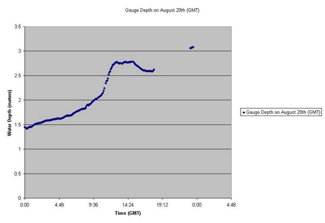
Note that the water level continues to rise sharply until 12:48 GMT. This may indicate when the levees started overflowing. The water level remains relatively steady until 15:12 GMT (9:12 am New Orleans time) when the readings start to decline. This may indicate when the levees started to breach, at a level of 2.785 meters (9 feet, 1 2/3 inches).
This new data alters "the only possible conclusion" of the previous update. The Ruminator had calculated a rise due to pumping of around three feet. The floodwalls of the 17th Street levee are twelve to fifteen feet high. Although I don't know if the pumps were actually operating at the time, the newly-discovered data seems to support my original hypothesis of human error: over-pumping may have overtopped and then destroyed the 17th Street drainage canal.
Note that the level continued to rise after the levee was breached, so it is unlikely intentionally flooding the city would have made a difference. Indeed, it may even have been preferable for the Canal floodwall to fail rather than that of the levee restraining Lake Pontchartrain itself; fixing a breach in the Lake levee may have been a much more difficult job.
For those readers upset over these vacillations, I apologize. In Science, one proceeds with the best data available. The assumptions behind the data may be at fault, or data may be missing, or the reasoning may be flat-out wrong. In this case, I assumed the storm peaked before 6:00 am New Orleans time so the original data was sufficient. I was wrong. My "human error" hypothesis may be wrong even now; if the recovery of the City of New Orleans was not at stake, I would not be "playing the blame game" so early in the process.
The Ruminator, a professional hydrologist, writes that he may continue to extend his model to include wind and wave action and refine it as more data is available. Interested readers may wish to check his site for further analysis.
Update 4, 9/8/05
From the Times-Picayune:
A rough reconstruction of the flooding based on anecdotal accounts, interviews, and computer modeling, shows that the huge scale of the overlapping floods – one fast, one slow – should have been clear to some officials by mid-afternoon Monday, when city representatives confirmed that the 17th Street canal floodwall had been breached...
The surge reached the Industrial Canal before dawn and quickly overflowed on both sides, the canal lockmaster reported to the Corps. At some point not long afterward, Corps officials believe a barge broke loose and crashed through the floodwall...
Sometime Monday morning, the 17th Street canal levee burst when storm surge waters pressed against it and possibly topped it, Corps officials said. Col. Richard P. Wagenaar, the corps’s site commander at 17th Street...
Naomi said he believes the breach occurred in the mid- or late-morning after the hurricane’s eye had passed east of the city. By that time, north winds would have pushed storm surge water in Lake Pontchartrain south against the hurricane levees and into the canals. Then the wind shifted to the west.
“As I remember it the worst of the storm had passed when we got word the floodwall had collapsed,” he said. “It could have been when we were experiencing westerly winds in the aftermath of the storm, which would have been pushing water against it.”
Naomi and other Corps officials say they believe that the water in the canal topped the levee on the Orleans Parish side, weakening its structure on the interior side and causing its collapse. However, Van Heerden said he does not believe the water was high enough in the lake to top the 14-foot wall and that the pressure caused a “catastrophic structural failure.”
It’s not clear when floodwalls in the London Avenue canal were breached, but Naomi said it may have been around the same time.
Once the floodwalls failed, water – then at about 8 feet or higher in the lake – began to pour into New Orleans from the west, beginning the full-scale nightmare...
Update 5, 9/9/05
From the Times-Picayune:
The corps and local officials also have restored 28 pumps in the New Orleans area, increasing the amount of water leaving the city to 9,000 cubic feet per second...As of Thursday morning, 60 percent of New Orleans was still under water...
Engineers have found that there were two breaches on the east side of the Inner Harbor Navigational Canal, and a third on the west side. That one would have added to the water entering the Lower Ninth Ward...Officials closed the larger of the two east breaches on Wednesday and were filling the smaller one with clay and stone on Thursday. Work will begin on the west side soon..."
***
Why did the local and state governments not implement their own emergency plans? It has been suggested that New Orleans Mayor Nagin appears to be functionally illiterate. This would explain his unfamiliarity with the emergency plans and emergency laws available to him.
Although the Army Corps of Engineers is responsible for the levee system, the City government operates the drainage pumps. Did Nagin instruct the pump operators to keep pumping regardless of the storm surge?
Consider this quote from an August 29th AP article in the Pittsburgh Post-Gazette:
Nagin said he expected the pumping system to fail during the height of the storm. The U.S. Army Corps of Engineers was standing by to get the system running, but water levels must fall first, the mayor said.
So Nagin expected - the implication is that he actually ordered - the pumps to keep operating until they were overwhelmed by the storm.
***
From the McGraw-Hill Engineering News-Record:
Officials now surmise that as the storm surge overtopped the flood walls at 17th St. and London Canals, it scoured their earthen foundations, causing panels to blow out. At the Inner Harbor Navigational Canal, aerial photographs show a barge nearly as long as one of two breaches in the canal’s east wall, indicating the vessel may have struck the wall, causing it to fail. "But we can’t really be sure until we can inspect the sites and do a forensic analysis of the cause of failure. It could well be that there were multiple causes for the failures at different places," says a weary Alfred C. Naomi, a hurricane protection system project manager who has been working on a drainage plan–the Corps calls it unwatering–since the storm pierced city flood walls...
On Sept. 5, the Corps stopped the hemorrhaging from the 17th Street Canal. For days, Chinook and Black Hawk helicopters had been placing large sandbags in the hole. The sandbags broke the surface of the water on Monday. Local contractor Boh Bros. Construction LLC was working simultaneously to plug the breach with rip rap from the north and to close the canal mouth with sheet piles. The contractor left a 40-ft gap in the center of the canal, Naomi says. "We want to keep the pressure off the side walls. We don’t really know what the structural integrity is until we can inspect them, so we’ll drain along the center line." That will minimize pressure on the intact west wall of the canal and the repaired east wall, he says...
With 17th Ave. draining, the Corps and contractors reported they had sheetpiled shut the mouth of the London Ave. Canal, except for a small gap to allow some drainage. Boh Bros. is building an access road and helicopters are sealing a breach there. Pumping will commence as soon as the canal is sealed.
Further east, the Inner Harbor Navigation Channel has one pump running, but also has two long breaches on its east side. Repairs are under way...
Update 6, 9/12/05
News from the Army Corps of Engineers, but not about the causes of the levee breaches:
Non-stop convoys of twenty-ton trucks delivered sand, gravel and large rock to areas on the 17th Street Canal where access roads had to be built to the breach there. The road was then forked from that location and built to reach the London Avenue Canal breach. From the London Avenue west side breach, the road is still being built today to the second breach area at Mirabeau Road. Corps contractors averaged building about 500 feet of roadway per day.
The next step at the 17th Street Canal, and later followed at the London Avenue Canal, was to cut off flow from Lake Pontchartrain into the canal. Corps contractors drove 150 of feet of steel piling across the canal to seal it.
Meanwhile, Texas Army National Guard Chinook and Blackhawk helicopter crews placed an average of 600 7,000-pound sandbags each day into the breaches. Depending on the helicopters lift capability, Corps riggers averaged one to three hookups every two minutes during daylight hours. Sandbagging operations ran 24 hours for ten days and, with the breaches complete, were halted Sept. 10.
Original estimates for completing the un-watering of the city have recently been revised...As of today, we estimate the overall un-watering effort will be completed in early to mid-October...The priority of the Corps is to support efforts to save lives and find people, sustain lives, and set conditions for recovery...
There are 148 organic pumps in the New Orleans area that are being worked. On Sept. 10, an average of 26 pumps were operating, pumping 9,125 cubic feet per second (cfs) and 39 portable pumps were operating, pumping 723 cfs. In addition, nine of 26 existing pumps in Plaquemines Parish reported operating at 1,360 cfs.
As of midnight Sept. 11, three-quarters of a billion gallons of water was being drained - or, the equivalent to an Olympic-sized swimming pool every two seconds...
Once unwatering is complete, several critical processes need to take place, including debris removal, structural assessments and restoration of critical utilities.
I hope debris removal won't begin until the failure assessment of the levees is underway. The pattern of the levee debris may indicate just how they failed, whether from "under-seepage" (concrete floodwall cantilevers inward due to liner, construction or design failure undermining earthen support) or "overtopping" (concrete floodwall fails outward due to overflowing canal turning the berm outside the canal to mud.)
Also: Current pump status of flooded levees, and background on levee funding.
Here is a review of the Army Corps of Engineers performance in previous levee crises.
The U.S. Geological Survey has this extensive paper on levees and flood control. (I have yet to peruse it.)
Professional engineers may wish to examine this paper: Numerical Simulation of Flood Inundation Due To Dam and Levee Breach.
And another blogger asking the "Why?" question here.
Update 7, 9/14/05
The Times-Picayune produced this excellent graphic of the New Orleans levee system two years ago. It is a little dated, especially since the breached sections of the 17th Street Canal were upgraded in the months before Hurricane Katrina struck.
Now, consider the T-P's own article Mystery surrounds floodwall breaches:
Ivor Van Heerden, who uses computer models to study storm-surge dynamics for the LSU Hurricane Center, has said that fragmentary initial data indicate that Katrina's storm-surge heights in Lake Pontchartrain would not have been high enough to top the canal walls and that a "catastrophic structural failure" occurred in the floodwalls...
"...They could have been overtopped. There could have been some structural failure. They could have been impacted by some type of debris," Naomi said. "I don't think it's right to make some type of judgment now. It's like presuming the reason for a plane crash without recovering the black box..."
...Suhayda said that his inspection of the debris from the 17th Street Canal breach suggests the wall simply gave way. "It looks to have been laterally pushed, not scoured in back with dirt being removed in pieces"...He suggested that because the walls failed in a few spots, the flaw may not be in the design but in the construction or materials...
...The central question for engineers investigating the breaches will be whether the floodwalls were topped - and that's still unclear...Many storm surge gauges stopped functioning during the storm...
...If the water did not top the levees, the breaches could prove more mysterious. Typically, the pounding of wave action would be the most likely way to cause a breach, scientists say. But there isn't much wave action in canals...
Not one word about whether over-pumping caused the levees to breach! (Yes, Suhayda may know about this blog...I tried to email it to him last week.)
Update 8, 9/16/05
The latest from The Times-Picayune, Jeff pump operators gone 24 hours:
Jefferson Parish [the parish (county) immediately west of Orleans parish] officials want to start the 2006 hurricane season with “safe houses” to shelter drainage station crews from deadly winds and storm surges, so they can keep the pumps operating during tropical storms and other heavy rains.
Design of the safe houses began this summer. But that was no help during Hurricane Katrina when the crews at Jefferson’s 18 major pump stations were evacuated to the north shore for more than 24 hours...
...a timeline pieced together during discussions with evacuees and representatives of several government agencies indicates that the pumps might have been down from Aug. 28 at about 7 p.m., when the crews were evacuated, until they returned and began restarting the pumps late on Aug. 29 and early the next morning. The eye of Katrina, a strong Category 4 hurricane, passed over the Gulf Coast the morning of Aug. 29.
Congemi and East Jefferson Levee District personnel, who didn’t evacuate, agree that street flooding began Aug. 29 after sunrise and gradually increased. Residents in some Metairie and Kenner neighborhoods began reporting home flooding late that afternoon.
“It’s sad to say, but maybe this disaster is what it takes to get the federal government to realize that they can’t keep turning a cold shoulder when we tell them we have to have more flood control projects and coastal restoration and our pump-to-the-river project that will put some of this water into the Mississippi River, so that it doesn’t have to all flow north to these pump stations on Lake Pontchartrain,” Congemi said.
Congemi thinks that flooding might have been aggravated by the pumps being off while operators were evacuated. But he thinks some flooding was inevitable.
“It’s just a shame that things were difficult to get our operators back to the pump stations...”
Administration officials said it’s too soon to start second-guessing how the lack of pumps might have aggravated flooding north of Interstate 10 between the St. Charles Parish line and Causeway Boulevard area...
Stop. Think! As far as I know, not one of the levee breaches (as opposed to just over-topping) occurred in Jefferson Parish. The 17th Street Canal divides Jefferson from Orleans Parish and is apparently run by the City of New Orleans itself -- where presumably the pumps kept on working until they were overwhelmed. There the floodwall breached on the Orleans side.
No one other than The Ruminator and I seem to be advancing the possibility that over-pumping destroyed the levees and floodwalls of the drainage canals, as the calculated three-foot rise created by pumping seems to be just enough to overtop the floodwalls of the 17th Street Canal. But local officials don't seem to acknowledge that this may even be a possibility, and perhaps Jefferson Parish may have sufferred a worse fate if their pump operators had been on the job during the surge.
Correction, 9/27/05: Reader G.B. writes:
The difference between what happened in Jefferson Parish and New Orleans isn’t due to the fact that pumps weren’t operating in Jefferson Parish. Quite to the contrary, it was the operators on the west (south) side of the Mississippi who evacuated. The operators in east (north) Jefferson Parish (west of the 17th Street Canal) stayed on the job. The difference is in the design of the local flood control system. As you can see in satellite imagery of the city, all of the pumping stations in east Jefferson Parish are located on the lake shoreline, and thus there are no outfall canals.
Correction 2, 10/7/05:
It is now claimed that The Jefferson Parish pump operators had indeed been evacuated.
Update 9, 9/19 & 9/20/05
Incredible! (As in scarcely believable):
Washington [DHS] officials were unable to confirm that the levees in New Orleans had failed until midday Tuesday, Aug. 30. The breaches first were discovered in Louisiana some 32 hours earlier.
There is something very, very wrong in this story. The levee breaks were first known on the 29th. It seems more likely that federal officials (at least the DHS ones) didn't understand the implications immediately. Apparently no one with a civil engineering background was available in whatever Department of Homeland Security "Situation Room" was monitoring Hurricane Katrina events. Bad, bad, bad. Some claim that FEMA has gone downhill since the Clinton years. That still doesn't absolve local and state officials from their primary responsibility (through omission or commission) for turning this disaster into a catastrophe, rather than an awful but managable mess.
*
After the floodwalls failed, more troubles occurred: Corps of Engineers Admits Sandbag Error:
Before Hurricane Katrina struck, the government should have had more sandbags and helicopters near New Orleans, ready to repair damaged levees, the commander of the Army Corps of Engineers said...
Levee expert Richard Van Bruggen...agreed that if either federal or local authorities had put the right equipment in place, repair work on levees could have been started a couple days earlier.
"Stockpiling has never been the mind-set of the Corps..."
So how did the levees finally get patched? Behold a hero. His name is Jerry Long:
When the major breaches in New Orleans' levees were plugged earlier this month, the solution didn't come from an Army Corps of Engineers contingency plan or a Federal Emergency Management Agency guide.
Instead, a Colorado-based engineer with a specialty in nuclear cleanups and a personal stake in the Hurricane Katrina disaster saved the day with a suggestion to fashion giant sandbags out of the fabric sacks his firm used to haul radioactive dirt. He helped rush thousands of the sacks to New Orleans, where they became the 16,000-pound sandbags that finally stopped the flood of water...
*
A devastated former New Orleans official provides background on the separation of pumping and levee responsibilities, courtesy of the Macon Telegraph.
*
An excellent interactive map, updated daily, of floodwater depth in New Orleans is provided courtesy of C & C Technologies. If you want to take Mayor Nagin up on his offer to let owners back into the city to inspect their property, you may wish to click on the nearest intersection to see if it is still underwater first.
This map also estimates the maximum water depth during the course of the flood. This suggests to me a possible way to analyze the failure of the 17th St. Canal floodwall. This floodwall collapsed on the New Orleans side only. The Jefferson Parish side did not fail, and a "Lake Metairie" formed, a puddle isolated from all other floodwaters.
I know of no possible sources of floodwater for this area other than rain and overflow from the 17th Street Canal before it was breached. If the max water depth is known, the volume of floodwater is known with equal accuracy. Assuming that water overflowed from the Canal before the breach, and that the N.O. & Jefferson floodwalls are of equal height, half of the overtopping waters should have flowed into Jefferson Parish.
The time the canals started overflowing before floodwall breach can be guessed from the East Bank 1 data and precipitation from surviving rain gauges, so one can calculate with fair accuracy the average flow rate of floodwaters into Metarie in the hours before the floodwalls failed. If this average is on the order of half the drainage pumping rate or less, I suppose one can state that over-pumping caused the Canal to overtop and fail with some degree of certainty. If the average is somewhat greater than half the pump rate, one can state that pumping only contributed to the over-topping, making it worse. And if the average is very much greater than the pump rate, one can guess that the drainage pumps made little difference at all.
This analysis cannot be used to determine the cause of floodwall failure with certainty, because only an average flood rate can be calculated, yet the available stage data suggests the storm surge increased quickly, so the rate of flooding must have been increasing rapidly before the floodwalls finally breached. But it does give an idea of what was going on, and should at least settle the question of whether or not the floodwalls were overtopped or (if calculations determine Lake Metairie formed due to rain only) whether they experienced structural failure through some design or construction fault.
Update 10, 9/20/05
Engineers Race to Patch Fractured Levees:
"The protection is very tenuous at best," said Dave Wurtzel, the Army Corps official responsible for repairing the 17th Street Canal levee, whose huge breach during Katrina caused the worst of the floods that wrecked the city.
In anticipation of another hurricane, the Corps drove massive metal barrier across the 17th Street Canal bed to prevent a storm surge from Lake Pontchartrain from swamping New Orleans again. Although engineers have left a large opening in the wall to allow floodwater to continue to be pumped back into the lake, it will have to be closed quickly if Rita or another storm threatens.
"This is what we're going to have to rely on to protect this canal and this part of the city," Wurtzel said.
It's not just that. Until it is determined why the levees failed, no one can tell for sure that any storm that rains enough to load the concrete floodwalls of the drainage canals won't cause another breach to the city's defenses.
Update 11, 9/21/05
In today's Washington Post: Experts Say Faulty Levees Caused Much of Flooding:
The Army Corps of Engineers has said that Katrina was just too massive for a system that was not intended to protect the city from a storm greater than a Category 3 hurricane, and that the floodwall failures near Lake Pontchartrain were caused by extraordinary surges...but...scientists and engineers at Louisiana State University's Hurricane Center have concluded that Katrina's surges did not come close to overtopping those barriers. That would make faulty design, inadequate construction or some combination of the two the likely cause of the breaching of the floodwalls along the 17th Street and London Avenue canals -- and the flooding of most of New Orleans...
"We are absolutely convinced that those floodwalls were never overtopped," said van Heerden, who also runs LSU's Center for the Study of Public Health Impacts of Hurricanes....[but]Corps spokesman Paul Johnston said the agency still believes that storm surges overtopped the concrete floodwalls near the lake, then undermined the earthen levees...
...researchers showed numerous indications that Katrina's surge was not as tall as the lakefront's protections. They showed a "debris line" that indicates the top height of Katrina's waves was at least four feet below the crest of Lake Pontchartrain's levees. They also pointed out how the breached floodwalls near the lake showed no signs of overtopping -- no splattering of mud, no drip lines and no erosion at their bases. They contended that the pattern of destruction behind the breaches was consistent with a localized "pressure burst," rather than widespread overtopping.
The center has also completed a computerized "hindcast" of Katrina, which has confirmed the evidence before their eyes. Their model indicates that most of the surge around the lake and its nearby canals was less than 11 feet above sea level, and that none of it should have been greater than 13 feet. The Army Corps's flood-protection system for New Orleans was designed to handle surges of more than 14 feet above sea level...
Former representative Bob Livingston (R-La.), who helped lead the charge for Corps projects in Louisiana when he chaired the House Appropriations Committee, noted that the earthen levees along Lake Pontchartrain had all held, while the concrete floodwalls had failed. He was especially concerned about the 17th Street barrier, saying it "shouldn't have broken...I don't know if it's bad construction or bad design, but whoever the contractor is has a problem..."
So, either the Corps - which is needed to keep the city dry - is to blame, or else the scientists & engineers - whose skills are needed to redesign the city so it stays dry in the future - are wrong. A very unpleasant situation. But did the LSU scientists factor in the rise in canal levels due to drainage pumping, as discussed in previous updates?
*
An anonymous eyewitness (he claims he is under a gag order) alleges kickbacks and sub-standard materials in the levee contracting process, and cautions us to be aware of disappearing evidence. He presents too much detail for me to dismiss him as a crank:
I am an eyewitness that some govern-ment contracts were awarded based on kickbacks. Some Construction Co's bought unstable substandard materials from some steel equipment co. employees. Inspectors of on site building materials were bribed. This is far-reaching & wide spread! New Orleans is still in severe danger! Who knows which portion of one of the substandard building sites (dam-bridge-levee) may go next? For God's sake think hard and act immediately because it is not over! There have been indictments that never made publicity nor penalty other than fines while the substandard building continued under the noses of some officials. I declared that New Orleans would go under water and that thousands would be killed if the substandard building wasn't stopped...My then Atty was Patricia Hedges (who shortly there-after became a Judge) told me that I had better keep my mouth shut...I wasn't even allowed to talk to AUTHORITIES...ASK QUESTIONS NOW before the evidence is removed, stolen, buried, or put under water. I CAN provide names...I am not saying these people are involved in criminal activity, I am saying they know that I speak the truth...When Ted Koppel said that this catastrophe was unfore-seeable, he was badly misinformed...I don't know how Beau Chene Estates fared during the hurricane. I know that a trench was being dug (in the 80's) and a young man was buried alive. Substandard material was used at that particular job site, but after the boy's body was removed, did the substandard material get replaced with material that met specs?
If proof can not be found of malfeasance, it is usually appropriate to ask if checks and balances were in place and operational to prevent it. If so, such anonymous allegations can be dismissed. If not, one must ask why the checks and balances didn't exist, and anonymous charges gain some credibility. In this case, "aard2hear" claims to be under a gag order. Something smells very rotten here.
*
The New York Times has unleashed some of its excellent science writers to attack levee failure issues, and today's edition has a lot to offer:
Design Shortcomings Seen in New Orleans Flood Walls:
...Other questions surround the walls' design, known as an "I-wall" for its slim cross section that fits easily into densely developed areas.
The corps manual for flood control construction suggests a different design for walls higher than seven feet - walls shaped like an inverted T, with the horizontal section buried in the dirt for extra stability, but that option was never considered, corps engineers said, because "T walls" were more expensive, required a broad base of dense soil for support and were not necessarily stronger...
I am astounded. I never assumed that the Corps would choose anything other than a "T wall". If the ground wasn't stable enough for a "T", then an "I" could only work if it plunged deep below ground. The center-of-gravity of an "I" is quite different from a "T". Did it rise above the level of the earthen levees? That would be a very big no-no, for any break in the plastic liner would weaken the earth below, and the floodwall could then easily have cantilevered outward at a water level below the design load.
A graphic of the levee construction is offerred here, and at once I can spot one thing I would have done differently: set the reinforcing steel rods at intersecting and mutually strengthening diagonals, rather than straight verticals.
For those who desire even more detail, there is a link to the Army's Levee Design Manual. (No, I'm not going to read it.)
Corrections and additions, 9/27/05: G.B. writes:
The New York Times article references the wrong Corps of Engineers design manual (no surprise). That one references the building of earthen levees, not floodwalls. The two relevant Corps design manuals are here:
EM 1110-2-2502 Engineering and Design - Retaining and Flood Walls
EM 1110-2-2504 Engineering and Design - Design of Sheet Pile Walls
Note that the cantilever I-wall design is a standard Corps design where there are space constraints as is evident along the outfall canals. The apparent weakness in the design is in the event that there is a significant reduction in the soil strength (which has its own engineering manual) particularly on the protected side of the wall. The two primary mitigation factors for this are to apply a factor of safety to the soil strength characteristics and scour protection on the lee side of the wall (“rigid paving within a 20- to 30-foot area of the wall”). Political considerations no doubt prevented the application of the latter (I seriously doubt if the neighborhoods would have let the Corps pave over 20 feet of their backyards to mitigate the effects of a 1 in 300 year flood event, especially given the response of many of the city’s residents to the warning that a Cat 5 hurricane was coming right for them.). One thing that does surprise me is that in order to avoid compounding factors of safety that there is no factor of safety applied to the design loads.
Update 12, 9/22/05
Yesterday I wrote this note to G. Paul Kemp, the Director of the Natural Systems Modeling Group at Lousiana State University who was cited in yesterday's Washington Post article:
Professor, do you know if the drainage pumps of the 17th Street Canal were operating during the surge? Is their rise and energy slope factored into flood modelling? I discuss this issue here:
http://solomon2.blogspot.com/2005/09/on-levees-of-new-orleans.html
Could the evidence cited in today's Washington Post article, cited as pointing to structural failure, equally apply to overtopping due to overpumping? Professor Thompson at Texas Tech seems to endorse over-pumping as a possibility: http://randomruminations.net/2118/the-analysis-begins
Respectfully,
- Solomon2
To this inquiry Dr. Kemp responded politely and promptly:
I don't know if the pumps were operating, but I think not. No, any pumping that was taking place was not factored in. Others have suggested overtopping, and that certainly happened on the Industrial Canal, but overtopping leaves fairly obvious signs wherever it does not result in complete failure (ie. excavation of a trench on the back side, etc.). Those signs were not there. Good questions though. Best, Paul
G. Paul Kemp, Ph.D.
That seems to be a most definitive answer. I had expected that evidence of "scouring" behind the floodwalls would be covered by mounds of sandbags, but Dr. Kemp, the man-on-the-spot, can discover enough evidence to rule this out. Just like bristles on a brush, the concrete floodwalls of the drainage canals of New Orleans parted or bent and thus released their drowning floodwaters into the City.
It is now up to the Army Corps of Engineers to justify their contention that any significant overtopping of the 17th Street Canal occurred before its floodwalls failed entirely.
* See disclaimer in the comments thread for this post.
Update 13, 9/23/05
I sent a short note to several people at the Corps of Engineers alerting them of yesterday's Update, and I have already received a short but prompt response:
Hi, and thanks for the note. We think the fact there were boats on both sides of the levee before any breaching occurred strongly suggests overtopping took place . . .
That's all of it. I didn't expect or request a response so soon, and given the fact that the Corps is tremendously busy at the moment, it is unfair to expect more at this time.
*
Yesterday's AP story, as published in The Houston Chronicle
Government auditors are questioning whether several multimillion-dollar Katrina contracts...invite abuse...[t]he contracts, for services such as levee repair and emergency housing, were granted to companies based on their pre-existing business relationships with the government. Critics say the arrangements foster cronyism because a few repeat players typically get the best deals...
"We've been looking at all the contracts from day one," said Richard Skinner, the Homeland Security Department's inspector general. "One concern is whether you are getting the fair market value. The second is whether the people we are giving contracts to are the best qualified."
Are these the same contractors entrusted with building or rebuilding the levees and floodwalls in the first place? Can a trustworthy chain of forensic engineering evidence be maintained under these circumstances?
*
"Our worst fears came true." Water Pours Into New Orleans' Ninth Ward:
...Dozens of blocks in the Ninth Ward were under water as a waterfall at least 30 feet wide poured over and through a dike that had been used to patch breaks in the Industrial Canal levee. On the street that runs parallel to the canal, the water ran waist-deep and was rising fast. Guidry said water was rising about three inches a minute.
As The New York Times noted, leaks from the Industrial Canal had already begun on a small scale yesterday:
Small waterfalls of leakage could be seen several feet below the top of the repaired levee as wind pushed rising water from Lake Pontchartrain through the Industrial Canal.
This was to be expected, said Chad Rachel, a civil engineer with the corps, after an inspection of the repaired breaches. There did not appear to be any erosion of the compacted clay base of the patched dike, he said, adding that he felt certain the large, interlocking stones atop the base would be able to withstand the expected storm surge.
"We don't expect any problem with a catastrophic breach," Mr. Rachel said.
By dusk, however, water had continued to rise, and Maj. Barry Guidry of the Army offered a direr assessment after examining the leaking at the Industrial Canal. "The levee's going to cave in," Major Guidry said. "In the middle of the night, this thing is going to be gone."
A prediction that has sadly come to pass.
Update 14, 9/23/05 2pm
Fox has a report that the 17th Street Canal is leaking, with water only 2 feet from the top. (Hat tip: Protein Wisdom.) I hope that nobody is trying to pump water through this canal during this storm surge.
Update 15, 9/23/05 3:30pm
Near real-time data shows Lake Pontchartrain Basin stage increasing rapidly. (Go to "View Previous", choose "1 Day", and click "Submit".) I do not comprehend the real-time data available from the temporary gauges.
Update 16, 9/25/05
Levee updates from the Corps of Engineers, courtesy of the Times-Picayune:
The temporary steel sheet pile closures at the 17th Street and London Avenue canals remain in place. Closures are preventing storm surge from Lake Pontchartrain from entering the canals and overtopping the temporary rock and earthen repairs to the damaged canal walls. Once the lake level equalizes, the Corps will remove the sheetpile and restore pumping.
• It was impractical to close off the Industrial Canal with sheetpile as was done at the outlets to the 17th Street and London Avenue Canals because it is too big...
The good news, Hitchings said, was that there was no breach or overtopping of the repairs made to the 17th Street Canal and the London Avenue Canal made after Katrina’s visit three weeks ago.
He said there was some “seepage form the London Avenue Canal’’ because of sandbags that were not aligned perfectly and allowed some water to flow through.
Update 17, 9/27/05
Engineers examining why floodwalls failed:
...The Army Corps of Engineers says it has begun to investigate the collapses. Scientists from Louisiana State University also are examining the damage, and the American Society of Civil Engineers will soon dispatch its own experts to the breach sites...
"There is some sense of urgency here, because if you go in and cover it with sandbags, you will still have to get in there and to look at what happened..."
In some places, it will be a relatively easy call. In the Industrial Canal, evidence shows that high water flowed over the tops of floodwalls and through sandbagged gaps, creating breaches and extensive flooding. In one spot on the east side of the canal, a barge appears to have struck the floodwall, contributing to a large breach and accelerating the flooding of the Lower 9th Ward. That breach was temporarily patched but reopened last weekend when Hurricane Rita's storm surge raised water levels again.
But it's not clear whether water topped some of floodwalls in the 17th Street and London Avenue canal systems. If it didn't, that means the stresses from high water may not have exceeded a given wall's designed capabilities - but it failed anyway, raising serious questions about long-term issues.
Ivor Van Heerden, deputy director of the LSU Hurricane Center, believes the walls at the 17th Street Canal, and possibly in the London Avenue Canal, failed without being topped. The corps says it's too early to draw conclusions.
Van Heerden said he and his colleagues measured a maximum storm surge height of 10.2 feet near the opening to the 17th Street Canal, and about 11 feet adjacent to the London Avenue canal. The original design specifications call for walls high enough to stop a storm surge of 11.2 feet at the lakefront...
...one focus will likely be the soil...when pressure quickly rises on one side, that can push earth as well as water underneath a floodwall...
Van Heerden said his survey of the levees showed that some broken walls had sheet pile bases extending only 2 or 3 feet down. Dan Hitchings, director of the Corps Mississippi Valley Division forward team working in New Orleans, said that the corps is examining the sheet piling depth as a possible issue in the failures.
Al Naomi, the Corps project manager who oversees the levee system, said he did not believe that water and soil were seeping from one side of levee walls to the other...
The steel reinforcing bars built into the concrete will be another target for investigators. Eagar said that in recent years a number of structural failures in buildings have been traced to faulty welding in such bars. In the floodwalls, the reinforcing rods appear to have been attached to the sheet piling, a photograph Van Heerden took shows, though it's not clear exactly how.
A big question underlying all of this is, if the walls were not topped by flood water, and engineers had built a significant safety factor in, how could the walls have failed? Van Heerden says his documents show the walls were designed to withstand 2.5 times the force that a Katrina-like hurricane could dish out.
Eagar said that even small design problems can compound one another, however. If five elements were off by 20 percent each, he said, statistically that would account for the 2.5 times safety factor.
All good questions. I would add another one: Why were joints between the floodwalls like this considered adequate? It looks like little other than a strip of rubber.
*
I have had the pleasure of receiving a long letter from reader G.B. I have posted several of his corrections and additions at various updates. Here I will point to an article he noticed but I missed: Pace of drainage is rare bright spot. Who can doubt the courage of the pump operators?
The challenge of "dewatering" the city, to use the fashionable term for pumping it dry, is being met by a group of about 300 water board engineers and pump operators who stayed on the job in Hurricane Katrina's aftermath at sometimes harrowing risks.
They briefly abandoned their posts when the waters got so deep that pumps' motors fried and the possibility of drowning was real...
...At one point, a massive set of ancient wooden doors was ripped off its hinges, nearly flattening a group of employees, said one of the chief operators at the Melpomene Pumping Station No. 1...
...But a few hours after the storm passed, there was cause for optimism. New Orleans seemed to have dodged a bullet. The operator was getting ready to shut off his pumps because the area was dry. "Everyone thought, 'OK, it's over with,'" he said. "Nobody knew about the breach. Then I saw water running down Broad Street. I ain't ever seen that."
Within 48 hours, the group had to be rescued and brought to another pumping station that was still dry: Pumping Station No. 6 on Metairie Road, which dumps directly into the 17th Street Canal...
...One group of operators at Pumping Station No. 5 had to swim to safety...Another group of 12 men got trapped at Pumping Station No. 4 on the London Avenue Canal..."These guys got flooded, and they made a makeshift boat out of a fence..."
A number of employees said that they thought their pumps could have done the job had the levees done theirs.
"We had this hurricane beat, man," said Bob Moeinian, superintendent of pumping, shaking his head in frustration. "If the levee had not broken, we'd be just like the West Bank: street cleanup and power outages...
...the pumps are strong enough to push a rippling current of water toward the lake -- indeed, so strong a current that officials must be careful not to stress the plugged breach in the 17th Street Canal. But for that concern, the Melpomene Pumping Station No. 1 on South Broad Street would be up and running. For the time being it is being held in abeyance because it dumps into the 17th Street Canal and might overwhelm it...
Perhaps that's how this levee breached in the first place. However, another reader, D.S., claims that "the pumps wree all off-line by mid-morning", citing a friend who is a friend of a pump supervisor as her source.
G.B. writes:
Now consider what’s near the outlet of the 17th Street Canal, the newly upgraded hurricane proof Hammond Street Bridge. Check out this Corps picture (warning large jpeg). Note the large amount of debris that piled up against the north (lakeside) side of the bridge (This is really evident in the NOAA aerial image). This would indicate that the canal level rose at least to the height of the bridge sidewalls. I’m not a professional photo interpreter, but it appears to me that the clearance between the normal water level and base of the bridge is at most 8 feet. If the lake level was already at ~6 ft according to the East Bank gage by 0300 on 29 Aug, it wouldn’t take much additional level rise in the canal for the bridge to start acting like a sluice gate, causing the water level to rise even more. If you throw in the flow resistance of the bride pilings, it’s not difficult to see that overtopping caused by “over-pumping” is wholly supportable.
Likewise, with a combined capacity of 7820 cfs ( PS #3 = 4140 cfs, PS #4 = 3680 cfs) the London Street canal flow approaches that of the 17th Street canal. Note the relative locations of the levee breaches along the London Street canal. They both occurred within the proximity of a bridge. The breach near the Robert E. Lee Blvd Bridge is almost a mirror image of the 17th Street canal breach, while the breach near the Mirabeau Ave. Bridge is more likely the result of more complex hydrodynamic interactions.
One more observation in support of the “over-pumping” theory. There is a third outfall canal, the Orleans canal between the 17th Street and London Ave canals. If the floodwall failures were due to poor design or construction, or the storm surge effects of the hurricane, why were there no failures along this canal? After all, it was exposed to the same hurricane forces and all of its design characteristics are similar to the other two canals, including being lined with floodwalls of the same cantilever I-wall design. Then what is the distinguishing difference? Could it be that the capacity of its pumping station, PS #7, is only 2690 cfs, roughly 1/3 of the other two canals?
...if you use the maximum pumping capacity, the same Manning value, and slope values between .00014 and .00019 (3/4 to 1 ft/mile), converging values of the velocity equations give a water depth of between 14 and 15 ft. If you consider that the normal no flow/low flow canal depth is probably no more than 10 ft given Lake Pontchartrain’s bathymetry and that it would impact the soil penetration of the sheet pile floodwalls (this is supported by the width to depth ratio of 25:1 to 30:1 referenced here), then the water level rise due to pumping at capacity would be at least in the 4 to 5 ft range (and more likely in the 6 to 8 ft range).
Now consider that this is the steady state flow model under normal conditions, and doesn’t even start to represent the transient conditions that were occurring at the time. By early morning on the 29th the storm surge had raised the lake level to more than 5 ft MSL. Lake water driven by 40 mph winds from the NW is flowing up the canal. It starts to rain heavily. The pump station operators start to crank up more and more pumps to keep up with the rain water runoff. Now you’re trying to drive water in a canal 2 miles long and 15 ft in the other direction, and to top it all off there’s a hurricane proof bridge creating a flow restriction at the canal’s outlet.
This culvert-like flow restriction was also noted by PETN Sandwich in the Comments section. Just looking at that photo makes me feel ill, for the restriction created by the bridge essentially lops a couple of effective feet off the height of the floodwalls, and narrowed an already-high level of flow to a higher, narrower passage. G.B. continues:
As to the LSU experts’ preoccupation with the lack of evidence of scouring or trenching behind sections that did not completely fail, I think the problem is that they are still viewing the issue of overtopping from the wrong perspective. They are trying to apply what happened in the Industrial Canal to the outfall canals, in which the storm surge raises the level of the entire body of water above the flood protection system and overtopping occurs along a wide stretch of levees. This would result in the trenching Prof. Kemp refers to and that can be seen in several of the photos of Industrial Canal levee breaches.
The floodwall failures in the outfall canals should be viewed from the perspective of a stream flow model (a familiar event for anyone who has experience irrigating hay meadows), in which the flowing water meets resistance (such as a dam or sluice gate), slowly rises, and seeks out a weakness or low spot along the floodwall, causing overtopping along a limited length of the wall. The protected side of the wall is scoured until there is insufficient soil strength to keep the wall from pivoting backwards, most likely near a joint (Note this image of the sheet piling which anchors the concrete walls. How much shear or lateral force do you think is required to separate the piling at the joints?) . Water rushes into the gap created on the canal side of the wall further reducing the soil strength. There is now 40+ feet of hydrostatic pressure (50,000 lbs/linear ft) acting on the canal side of the wall, causing it to lean even further or be pushed back against the lee side embankment. The breach provides a relief path for the rising waters to flow through, limiting or stopping overtopping along nearby sections. The waters rushing through the breach erode the supporting soil of adjacent wall sections, causing them to fail like dominoes until a steady state condition is reached. This is fairly well demonstrated in the various aerial images of the London Avenue Canal breaches.
As I wrote earlier, the joints appear to be just rubber flaps; very little shear force would be needed to separate them.
Update 18, 9/29/05
Nola.com has posted two photo galleries of inspections of the failed levees, as their photographers accompanied investigators from the Corps of Engineers and Louisiana State University. If you're into "concrete, rebar, and rubber" this is where you should go: (1) (2). I find photo #7 of Gallery 2 especially disturbing: it seems to depict a London Canal floodwall segment that remained standing, yet broke in the middle; some intact rebar and what appears to be a white plastic inner liner may have kept water from rushing out in full force, but the floodwall appears to have failed nonetheless.
*
Question: Louisiana's legal system has its roots in French and Spanish civil law, not English Common Law. The corruption or incompetence in this state seems to be extreme (BayouBuzz.com):
...former Orleans Parish Levee Board Chairman Billy Nungesser. For years, he alerted the public about the wasteful activities of the board and he chastised his fellow board members for their misplaced priorities. According to Nungesser, “Every time I turned over a rock, there was something rotten. I used to tell people, ‘If your children ever die in a hurricane, come shoot us, because we’re responsible...’
I wonder if the difference in legal systems may have something to do with this?
Update 19, 9/30/05
Writing in the comments section Lawhawk alerted me to the excellent MSNBC story yesterday, one that deserves to be read in its entirety: New Orleans levee reported weak in 1990s Records: Construction firm alerted engineers, but no action was taken:
NBC News has obtained what may be a key clue, hidden in long forgotten legal documents. They reveal that when the floodwall on the 17th Street Canal was built a decade ago, there were major construction problems — problems brought to the attention of the U.S. Army Corps of Engineers...
There already was an earthen levee made of soil. Embedded in that was a thin metal wall called sheet piling. The contractor was hired to pour concrete on top of all that to form the flood wall.
But the 1998 documents — filed as part of a legal dispute over costs — indicate the contractor complained about “weakness” of the soil and “the lack of structural integrity of the existing sheet pile....
“I think it is very significant,” adds Robert G. Bea, a former Corps engineer and professor...“It begins to explain some things that I couldn't explain based on the information that I've had....”
MSNBC even includes this link: Pittman's appeal to the U.S. Army (21 pages, PDF)
Things are heating up, because the official investigation into the cause of the levee breaks has begun (L.A. Times):
The Army Corps of Engineers said Wednesday it was launching a formal investigation into the failure of storm walls and levees in New Orleans during Hurricane Katrina...Since the Aug. 29 failure of three concrete walls that protected New Orleans from storm surges, Army engineers have issued a number of informal assessments and conclusions, but the organization had not moved forward until now with any formal investigation.
The probe is expected to take eight months, a corps spokesman in New Orleans said. The board has not yet been appointed but would include both corps and outside experts, run out of the corps' Washington headquarters, he added.
Disclosure of the investigation, however, left some experts in Louisiana arguing that the failures should be examined by an independent federal commission, similar to the board that studied the Columbia space shuttle accident...
The investigation will examine the design, construction and inspection of the storm wall system, as well as contract documents, to determine the causes of the failures, the Army spokesman said.
But Ivor van Heerden, deputy director at Louisiana State University's Hurricane Center, said wreckage from the storm walls should be removed from the canals to a site where a forensic engineering investigation could be conducted. He added that all of the diagrams and technical data involving the construction of the storm walls should be available to the investigation board.
"We suggested that just as in a criminal investigation, you gather all of the information and do a good analysis," Van Heerden said. "Instead, they are burying the wall segments that failed."
Van Heerden said a university engineering team had met with Army officials Tuesday night and agreed to begin conducting joint assessments of the failures at the site on Wednesday. But the planned trip was canceled for unknown reasons at the last minute, Van Heerden said.
The distinction between the two types of investigation is quite important. This post with its updates has addressed the macro-engineering aspects of the levee failures, and that's really all the Corps intends to investigate at the moment; certainly the Army possesses all of the expertise to do so.
I do not know why it would take eight months to complete. Perhaps X-ray inspections of the existing levees (such equipment is portable) will take the largest amount of time. But in eight months levee restoration will be nearly complete -- with no possibility of design or construction changes to make the rebuilt structures any stronger than before -- perhaps just a temporary fix, the opposite of the American Institute of Architects' recommended.
Yet only a detailed scientific investigation of the failure, including the levee soil mechanics mentioned in the LA Times article and right down to the microstructure of the concrete floodwalls will rule out the possibility of other deficiencies. This would be an investigation on a much larger scale, requiring work to be subcontracted with the government investigators - not just the Corps - mostly assuming a supervisory role, as only a fraction of the work could be done using the Corps' own resources. And that investigation would take many months.
(Such work is also the bread-and-butter of university laboratories, which may be one reason why Van Heerden advocates it. No one is a disinterested party here.)
I have never done forensic engineering work, but I'll just let my imagination go, save for soil mechanics, which I know nothing about:
My investigation of the levee failures would include these elements: strength testing of the concrete floodwall; notch-testing, microscopy, and x-ray diffraction (XRD) investigations of the steel reinforcing rods; and microscopy and leach testing of the concrete itself.
These tests would be performed at specific "sample points" chosen jointly by Corps' and University investigators. For each Canal, appropriate sample points would be at the middle and ends of the levee breaks, a few especially suspect pieces discovered on the ground, and one or two perfectly fine segments to be used as controls. That's about eight points each for the 17th Ave and Industrial Canals, and a dozen for the London Avenue Canal where two breaches occurred.
Each sample point would be examined by two or three different groups to assure quality work, and each group will need to be furnished with material to divide into enough samples to be statistically significant. About a dozen samples for each analysis, perhaps twice that for the microscopic evaluation of the heterogeneous concrete.
So each "sample point" generates about hundred samples for examination per group, three groups for redundancy, and twenty-eight sample points -- that's over eight thousand samples total. Assume twenty laboratories are awarded contracts: that's over 400 samples to be analyzed per laboratory.
How long does it all take? Writing the solicitation for research contracts: two weeks. Time for universities and private labs to read and respond with bids: three weeks. Awarding contracts: two weeks. Let's be generous and assume the selecting, cutting up, and cataloguing of material from the sample points takes place concurrently with this process. Shipping the material out to laboratories will still take at least two weeks.
Once material is received at the laboratory, cutting, grinding, polishing, and coating the samples for microscopy and XRD will weeks. A good lab can process perhaps five microscopy samples a day, so the sixty microscopy samples to be processed from each lab will take three months to process. The leach-testing process may take even longer, but we'll assume it takes about the same amount of time. The other investigations can be finished more quickly.
Finally, all the results need to be written up by the investigators and the samples and reports returned to be digested the supervisors. We're talking over six months of work here.
Compared to the decision of whether or not to implement a full scientific investigation, the question of whether or not an "independent" Challenger-like panel should run things seems rather puny. I do not recommend that the Corps or politicians or academics be empowered to decide what to do on their own. Rather, I advise the appointment of a federal Advisory Committee on Levee Safety that can guide politicians with its recommendations. Such low-key committees as the Advisory Committee on Reactor Safeguards have served the country well for decades.
Note: I am celebrating the one-month anniversary of this blog entry by "closing" this post; it is getting to be long and unwieldy. On the Levees of New Orleans, Book II continues this investigation.
hurricane+katrina
Normally, I would wait to analyze the question of who-is-at-fault until the first priorities of rescue and "unwatering" (via the city's drainage pumping system) are well underway. However, in this case the possibility exists that the "who-is-at-fault" issue may affect the city's recovery.
For it is not the breach of the levees holding back the Mississippi River that is swamping New Orleans but that of the 17th Street Canal, part of the system designed to drain the city. According to news reports, the Canal was first overtopped, and then the spilled waters undermined recently-constructed concrete retaining walls.
Why was the Canal so full of water? The largest drainage pumping station in the world feeds this Canal. The operators of the system may have been over-eager to pump out the City, and thus pumped too much too fast, overwhelming the Canal.
Therefore the bitter possibility exists that the Drowning of New Orleans is due to human error. As the slow recovery of The Big Easy progresses, the city's elected officials may wish to examine the competence of the pump operators. Not to create scapegoats, for who could suggest any lapse of good will and duty? - But to create a more effective partnership in rebuilding the city, and help ensure this doesn't happen again.
Update: 9/4/05
From the The Houston Chronicle (August 30th):
Engineers developed several possible scenarios for what might have caused the catastrophic breach in a levee, which is essentially an earthen berm topped by several feet of concrete.
Corps of Engineers officials said their analysis indicated that a limited amount of water washed over the top of the levee in waves, scouring and weakening the foundation on the levee's dry side.
Suhayda said that's possible. But another possibility is that, during the half-day floodwaters built up in Lake Pontchartrain and the canal, water may have percolated through the earthen part of the berm, undermining it.
Update 2, 9/4/05
The over-pumping theory is looking increasingly unlikely. The Ruminator has roughed out a calculation showing the effect to be quite small. The Shy Elf points to USGS data here (but more to the point, what I found here) that fit with storm-surge modeling data published in the Los Angeles Times showing Lake Ponchartrain surge levels less than 5½ feet. (True, the USGS data seems to have stopped at the height of the storm, but what we have fits with the computer model.)
As the Shy Elf says, "The only possible conclusion is that construction methods were incompetent, and that this disaster was bound to occur..."
Update 3, 9/6/05
I've discovered that data from another station ten miles west of the 17th street levee break is available: East Bank 1. This station survived a day longer than the West End station and it shows the water level of Lake Pontchartrain continued to rise after Hurricane Katrina passed, peaking at 3.26 meters (10 feet, 8 1/3 inches) late on the 29th (New Orleans is GMT-6).
Note that the water level continues to rise sharply until 12:48 GMT. This may indicate when the levees started overflowing. The water level remains relatively steady until 15:12 GMT (9:12 am New Orleans time) when the readings start to decline. This may indicate when the levees started to breach, at a level of 2.785 meters (9 feet, 1 2/3 inches).
This new data alters "the only possible conclusion" of the previous update. The Ruminator had calculated a rise due to pumping of around three feet. The floodwalls of the 17th Street levee are twelve to fifteen feet high. Although I don't know if the pumps were actually operating at the time, the newly-discovered data seems to support my original hypothesis of human error: over-pumping may have overtopped and then destroyed the 17th Street drainage canal.
Note that the level continued to rise after the levee was breached, so it is unlikely intentionally flooding the city would have made a difference. Indeed, it may even have been preferable for the Canal floodwall to fail rather than that of the levee restraining Lake Pontchartrain itself; fixing a breach in the Lake levee may have been a much more difficult job.
For those readers upset over these vacillations, I apologize. In Science, one proceeds with the best data available. The assumptions behind the data may be at fault, or data may be missing, or the reasoning may be flat-out wrong. In this case, I assumed the storm peaked before 6:00 am New Orleans time so the original data was sufficient. I was wrong. My "human error" hypothesis may be wrong even now; if the recovery of the City of New Orleans was not at stake, I would not be "playing the blame game" so early in the process.
The Ruminator, a professional hydrologist, writes that he may continue to extend his model to include wind and wave action and refine it as more data is available. Interested readers may wish to check his site for further analysis.
Update 4, 9/8/05
From the Times-Picayune:
A rough reconstruction of the flooding based on anecdotal accounts, interviews, and computer modeling, shows that the huge scale of the overlapping floods – one fast, one slow – should have been clear to some officials by mid-afternoon Monday, when city representatives confirmed that the 17th Street canal floodwall had been breached...
The surge reached the Industrial Canal before dawn and quickly overflowed on both sides, the canal lockmaster reported to the Corps. At some point not long afterward, Corps officials believe a barge broke loose and crashed through the floodwall...
Sometime Monday morning, the 17th Street canal levee burst when storm surge waters pressed against it and possibly topped it, Corps officials said. Col. Richard P. Wagenaar, the corps’s site commander at 17th Street...
Naomi said he believes the breach occurred in the mid- or late-morning after the hurricane’s eye had passed east of the city. By that time, north winds would have pushed storm surge water in Lake Pontchartrain south against the hurricane levees and into the canals. Then the wind shifted to the west.
“As I remember it the worst of the storm had passed when we got word the floodwall had collapsed,” he said. “It could have been when we were experiencing westerly winds in the aftermath of the storm, which would have been pushing water against it.”
Naomi and other Corps officials say they believe that the water in the canal topped the levee on the Orleans Parish side, weakening its structure on the interior side and causing its collapse. However, Van Heerden said he does not believe the water was high enough in the lake to top the 14-foot wall and that the pressure caused a “catastrophic structural failure.”
It’s not clear when floodwalls in the London Avenue canal were breached, but Naomi said it may have been around the same time.
Once the floodwalls failed, water – then at about 8 feet or higher in the lake – began to pour into New Orleans from the west, beginning the full-scale nightmare...
Update 5, 9/9/05
From the Times-Picayune:
The corps and local officials also have restored 28 pumps in the New Orleans area, increasing the amount of water leaving the city to 9,000 cubic feet per second...As of Thursday morning, 60 percent of New Orleans was still under water...
Engineers have found that there were two breaches on the east side of the Inner Harbor Navigational Canal, and a third on the west side. That one would have added to the water entering the Lower Ninth Ward...Officials closed the larger of the two east breaches on Wednesday and were filling the smaller one with clay and stone on Thursday. Work will begin on the west side soon..."
***
Why did the local and state governments not implement their own emergency plans? It has been suggested that New Orleans Mayor Nagin appears to be functionally illiterate. This would explain his unfamiliarity with the emergency plans and emergency laws available to him.
Although the Army Corps of Engineers is responsible for the levee system, the City government operates the drainage pumps. Did Nagin instruct the pump operators to keep pumping regardless of the storm surge?
Consider this quote from an August 29th AP article in the Pittsburgh Post-Gazette:
Nagin said he expected the pumping system to fail during the height of the storm. The U.S. Army Corps of Engineers was standing by to get the system running, but water levels must fall first, the mayor said.
So Nagin expected - the implication is that he actually ordered - the pumps to keep operating until they were overwhelmed by the storm.
***
From the McGraw-Hill Engineering News-Record:
Officials now surmise that as the storm surge overtopped the flood walls at 17th St. and London Canals, it scoured their earthen foundations, causing panels to blow out. At the Inner Harbor Navigational Canal, aerial photographs show a barge nearly as long as one of two breaches in the canal’s east wall, indicating the vessel may have struck the wall, causing it to fail. "But we can’t really be sure until we can inspect the sites and do a forensic analysis of the cause of failure. It could well be that there were multiple causes for the failures at different places," says a weary Alfred C. Naomi, a hurricane protection system project manager who has been working on a drainage plan–the Corps calls it unwatering–since the storm pierced city flood walls...
On Sept. 5, the Corps stopped the hemorrhaging from the 17th Street Canal. For days, Chinook and Black Hawk helicopters had been placing large sandbags in the hole. The sandbags broke the surface of the water on Monday. Local contractor Boh Bros. Construction LLC was working simultaneously to plug the breach with rip rap from the north and to close the canal mouth with sheet piles. The contractor left a 40-ft gap in the center of the canal, Naomi says. "We want to keep the pressure off the side walls. We don’t really know what the structural integrity is until we can inspect them, so we’ll drain along the center line." That will minimize pressure on the intact west wall of the canal and the repaired east wall, he says...
With 17th Ave. draining, the Corps and contractors reported they had sheetpiled shut the mouth of the London Ave. Canal, except for a small gap to allow some drainage. Boh Bros. is building an access road and helicopters are sealing a breach there. Pumping will commence as soon as the canal is sealed.
Further east, the Inner Harbor Navigation Channel has one pump running, but also has two long breaches on its east side. Repairs are under way...
Update 6, 9/12/05
News from the Army Corps of Engineers, but not about the causes of the levee breaches:
Non-stop convoys of twenty-ton trucks delivered sand, gravel and large rock to areas on the 17th Street Canal where access roads had to be built to the breach there. The road was then forked from that location and built to reach the London Avenue Canal breach. From the London Avenue west side breach, the road is still being built today to the second breach area at Mirabeau Road. Corps contractors averaged building about 500 feet of roadway per day.
The next step at the 17th Street Canal, and later followed at the London Avenue Canal, was to cut off flow from Lake Pontchartrain into the canal. Corps contractors drove 150 of feet of steel piling across the canal to seal it.
Meanwhile, Texas Army National Guard Chinook and Blackhawk helicopter crews placed an average of 600 7,000-pound sandbags each day into the breaches. Depending on the helicopters lift capability, Corps riggers averaged one to three hookups every two minutes during daylight hours. Sandbagging operations ran 24 hours for ten days and, with the breaches complete, were halted Sept. 10.
Original estimates for completing the un-watering of the city have recently been revised...As of today, we estimate the overall un-watering effort will be completed in early to mid-October...The priority of the Corps is to support efforts to save lives and find people, sustain lives, and set conditions for recovery...
There are 148 organic pumps in the New Orleans area that are being worked. On Sept. 10, an average of 26 pumps were operating, pumping 9,125 cubic feet per second (cfs) and 39 portable pumps were operating, pumping 723 cfs. In addition, nine of 26 existing pumps in Plaquemines Parish reported operating at 1,360 cfs.
As of midnight Sept. 11, three-quarters of a billion gallons of water was being drained - or, the equivalent to an Olympic-sized swimming pool every two seconds...
Once unwatering is complete, several critical processes need to take place, including debris removal, structural assessments and restoration of critical utilities.
I hope debris removal won't begin until the failure assessment of the levees is underway. The pattern of the levee debris may indicate just how they failed, whether from "under-seepage" (concrete floodwall cantilevers inward due to liner, construction or design failure undermining earthen support) or "overtopping" (concrete floodwall fails outward due to overflowing canal turning the berm outside the canal to mud.)
Also: Current pump status of flooded levees, and background on levee funding.
Here is a review of the Army Corps of Engineers performance in previous levee crises.
The U.S. Geological Survey has this extensive paper on levees and flood control. (I have yet to peruse it.)
Professional engineers may wish to examine this paper: Numerical Simulation of Flood Inundation Due To Dam and Levee Breach.
And another blogger asking the "Why?" question here.
Update 7, 9/14/05
The Times-Picayune produced this excellent graphic of the New Orleans levee system two years ago. It is a little dated, especially since the breached sections of the 17th Street Canal were upgraded in the months before Hurricane Katrina struck.
Now, consider the T-P's own article Mystery surrounds floodwall breaches:
Ivor Van Heerden, who uses computer models to study storm-surge dynamics for the LSU Hurricane Center, has said that fragmentary initial data indicate that Katrina's storm-surge heights in Lake Pontchartrain would not have been high enough to top the canal walls and that a "catastrophic structural failure" occurred in the floodwalls...
"...They could have been overtopped. There could have been some structural failure. They could have been impacted by some type of debris," Naomi said. "I don't think it's right to make some type of judgment now. It's like presuming the reason for a plane crash without recovering the black box..."
...Suhayda said that his inspection of the debris from the 17th Street Canal breach suggests the wall simply gave way. "It looks to have been laterally pushed, not scoured in back with dirt being removed in pieces"...He suggested that because the walls failed in a few spots, the flaw may not be in the design but in the construction or materials...
...The central question for engineers investigating the breaches will be whether the floodwalls were topped - and that's still unclear...Many storm surge gauges stopped functioning during the storm...
...If the water did not top the levees, the breaches could prove more mysterious. Typically, the pounding of wave action would be the most likely way to cause a breach, scientists say. But there isn't much wave action in canals...
Not one word about whether over-pumping caused the levees to breach! (Yes, Suhayda may know about this blog...I tried to email it to him last week.)
Update 8, 9/16/05
The latest from The Times-Picayune, Jeff pump operators gone 24 hours:
Jefferson Parish [the parish (county) immediately west of Orleans parish] officials want to start the 2006 hurricane season with “safe houses” to shelter drainage station crews from deadly winds and storm surges, so they can keep the pumps operating during tropical storms and other heavy rains.
Design of the safe houses began this summer. But that was no help during Hurricane Katrina when the crews at Jefferson’s 18 major pump stations were evacuated to the north shore for more than 24 hours...
...a timeline pieced together during discussions with evacuees and representatives of several government agencies indicates that the pumps might have been down from Aug. 28 at about 7 p.m., when the crews were evacuated, until they returned and began restarting the pumps late on Aug. 29 and early the next morning. The eye of Katrina, a strong Category 4 hurricane, passed over the Gulf Coast the morning of Aug. 29.
Congemi and East Jefferson Levee District personnel, who didn’t evacuate, agree that street flooding began Aug. 29 after sunrise and gradually increased. Residents in some Metairie and Kenner neighborhoods began reporting home flooding late that afternoon.
“It’s sad to say, but maybe this disaster is what it takes to get the federal government to realize that they can’t keep turning a cold shoulder when we tell them we have to have more flood control projects and coastal restoration and our pump-to-the-river project that will put some of this water into the Mississippi River, so that it doesn’t have to all flow north to these pump stations on Lake Pontchartrain,” Congemi said.
Congemi thinks that flooding might have been aggravated by the pumps being off while operators were evacuated. But he thinks some flooding was inevitable.
“It’s just a shame that things were difficult to get our operators back to the pump stations...”
Administration officials said it’s too soon to start second-guessing how the lack of pumps might have aggravated flooding north of Interstate 10 between the St. Charles Parish line and Causeway Boulevard area...
Stop. Think! As far as I know, not one of the levee breaches (as opposed to just over-topping) occurred in Jefferson Parish. The 17th Street Canal divides Jefferson from Orleans Parish and is apparently run by the City of New Orleans itself -- where presumably the pumps kept on working until they were overwhelmed. There the floodwall breached on the Orleans side.
No one other than The Ruminator and I seem to be advancing the possibility that over-pumping destroyed the levees and floodwalls of the drainage canals, as the calculated three-foot rise created by pumping seems to be just enough to overtop the floodwalls of the 17th Street Canal. But local officials don't seem to acknowledge that this may even be a possibility, and perhaps Jefferson Parish may have sufferred a worse fate if their pump operators had been on the job during the surge.
Correction, 9/27/05: Reader G.B. writes:
The difference between what happened in Jefferson Parish and New Orleans isn’t due to the fact that pumps weren’t operating in Jefferson Parish. Quite to the contrary, it was the operators on the west (south) side of the Mississippi who evacuated. The operators in east (north) Jefferson Parish (west of the 17th Street Canal) stayed on the job. The difference is in the design of the local flood control system. As you can see in satellite imagery of the city, all of the pumping stations in east Jefferson Parish are located on the lake shoreline, and thus there are no outfall canals.
Correction 2, 10/7/05:
It is now claimed that The Jefferson Parish pump operators had indeed been evacuated.
Update 9, 9/19 & 9/20/05
Incredible! (As in scarcely believable):
Washington [DHS] officials were unable to confirm that the levees in New Orleans had failed until midday Tuesday, Aug. 30. The breaches first were discovered in Louisiana some 32 hours earlier.
There is something very, very wrong in this story. The levee breaks were first known on the 29th. It seems more likely that federal officials (at least the DHS ones) didn't understand the implications immediately. Apparently no one with a civil engineering background was available in whatever Department of Homeland Security "Situation Room" was monitoring Hurricane Katrina events. Bad, bad, bad. Some claim that FEMA has gone downhill since the Clinton years. That still doesn't absolve local and state officials from their primary responsibility (through omission or commission) for turning this disaster into a catastrophe, rather than an awful but managable mess.
*
After the floodwalls failed, more troubles occurred: Corps of Engineers Admits Sandbag Error:
Before Hurricane Katrina struck, the government should have had more sandbags and helicopters near New Orleans, ready to repair damaged levees, the commander of the Army Corps of Engineers said...
Levee expert Richard Van Bruggen...agreed that if either federal or local authorities had put the right equipment in place, repair work on levees could have been started a couple days earlier.
"Stockpiling has never been the mind-set of the Corps..."
So how did the levees finally get patched? Behold a hero. His name is Jerry Long:
When the major breaches in New Orleans' levees were plugged earlier this month, the solution didn't come from an Army Corps of Engineers contingency plan or a Federal Emergency Management Agency guide.
Instead, a Colorado-based engineer with a specialty in nuclear cleanups and a personal stake in the Hurricane Katrina disaster saved the day with a suggestion to fashion giant sandbags out of the fabric sacks his firm used to haul radioactive dirt. He helped rush thousands of the sacks to New Orleans, where they became the 16,000-pound sandbags that finally stopped the flood of water...
*
A devastated former New Orleans official provides background on the separation of pumping and levee responsibilities, courtesy of the Macon Telegraph.
*
An excellent interactive map, updated daily, of floodwater depth in New Orleans is provided courtesy of C & C Technologies. If you want to take Mayor Nagin up on his offer to let owners back into the city to inspect their property, you may wish to click on the nearest intersection to see if it is still underwater first.
This map also estimates the maximum water depth during the course of the flood. This suggests to me a possible way to analyze the failure of the 17th St. Canal floodwall. This floodwall collapsed on the New Orleans side only. The Jefferson Parish side did not fail, and a "Lake Metairie" formed, a puddle isolated from all other floodwaters.
I know of no possible sources of floodwater for this area other than rain and overflow from the 17th Street Canal before it was breached. If the max water depth is known, the volume of floodwater is known with equal accuracy. Assuming that water overflowed from the Canal before the breach, and that the N.O. & Jefferson floodwalls are of equal height, half of the overtopping waters should have flowed into Jefferson Parish.
The time the canals started overflowing before floodwall breach can be guessed from the East Bank 1 data and precipitation from surviving rain gauges, so one can calculate with fair accuracy the average flow rate of floodwaters into Metarie in the hours before the floodwalls failed. If this average is on the order of half the drainage pumping rate or less, I suppose one can state that over-pumping caused the Canal to overtop and fail with some degree of certainty. If the average is somewhat greater than half the pump rate, one can state that pumping only contributed to the over-topping, making it worse. And if the average is very much greater than the pump rate, one can guess that the drainage pumps made little difference at all.
This analysis cannot be used to determine the cause of floodwall failure with certainty, because only an average flood rate can be calculated, yet the available stage data suggests the storm surge increased quickly, so the rate of flooding must have been increasing rapidly before the floodwalls finally breached. But it does give an idea of what was going on, and should at least settle the question of whether or not the floodwalls were overtopped or (if calculations determine Lake Metairie formed due to rain only) whether they experienced structural failure through some design or construction fault.
Update 10, 9/20/05
Engineers Race to Patch Fractured Levees:
"The protection is very tenuous at best," said Dave Wurtzel, the Army Corps official responsible for repairing the 17th Street Canal levee, whose huge breach during Katrina caused the worst of the floods that wrecked the city.
In anticipation of another hurricane, the Corps drove massive metal barrier across the 17th Street Canal bed to prevent a storm surge from Lake Pontchartrain from swamping New Orleans again. Although engineers have left a large opening in the wall to allow floodwater to continue to be pumped back into the lake, it will have to be closed quickly if Rita or another storm threatens.
"This is what we're going to have to rely on to protect this canal and this part of the city," Wurtzel said.
It's not just that. Until it is determined why the levees failed, no one can tell for sure that any storm that rains enough to load the concrete floodwalls of the drainage canals won't cause another breach to the city's defenses.
Update 11, 9/21/05
In today's Washington Post: Experts Say Faulty Levees Caused Much of Flooding:
The Army Corps of Engineers has said that Katrina was just too massive for a system that was not intended to protect the city from a storm greater than a Category 3 hurricane, and that the floodwall failures near Lake Pontchartrain were caused by extraordinary surges...but...scientists and engineers at Louisiana State University's Hurricane Center have concluded that Katrina's surges did not come close to overtopping those barriers. That would make faulty design, inadequate construction or some combination of the two the likely cause of the breaching of the floodwalls along the 17th Street and London Avenue canals -- and the flooding of most of New Orleans...
"We are absolutely convinced that those floodwalls were never overtopped," said van Heerden, who also runs LSU's Center for the Study of Public Health Impacts of Hurricanes....[but]Corps spokesman Paul Johnston said the agency still believes that storm surges overtopped the concrete floodwalls near the lake, then undermined the earthen levees...
...researchers showed numerous indications that Katrina's surge was not as tall as the lakefront's protections. They showed a "debris line" that indicates the top height of Katrina's waves was at least four feet below the crest of Lake Pontchartrain's levees. They also pointed out how the breached floodwalls near the lake showed no signs of overtopping -- no splattering of mud, no drip lines and no erosion at their bases. They contended that the pattern of destruction behind the breaches was consistent with a localized "pressure burst," rather than widespread overtopping.
The center has also completed a computerized "hindcast" of Katrina, which has confirmed the evidence before their eyes. Their model indicates that most of the surge around the lake and its nearby canals was less than 11 feet above sea level, and that none of it should have been greater than 13 feet. The Army Corps's flood-protection system for New Orleans was designed to handle surges of more than 14 feet above sea level...
Former representative Bob Livingston (R-La.), who helped lead the charge for Corps projects in Louisiana when he chaired the House Appropriations Committee, noted that the earthen levees along Lake Pontchartrain had all held, while the concrete floodwalls had failed. He was especially concerned about the 17th Street barrier, saying it "shouldn't have broken...I don't know if it's bad construction or bad design, but whoever the contractor is has a problem..."
So, either the Corps - which is needed to keep the city dry - is to blame, or else the scientists & engineers - whose skills are needed to redesign the city so it stays dry in the future - are wrong. A very unpleasant situation. But did the LSU scientists factor in the rise in canal levels due to drainage pumping, as discussed in previous updates?
*
An anonymous eyewitness (he claims he is under a gag order) alleges kickbacks and sub-standard materials in the levee contracting process, and cautions us to be aware of disappearing evidence. He presents too much detail for me to dismiss him as a crank:
I am an eyewitness that some govern-ment contracts were awarded based on kickbacks. Some Construction Co's bought unstable substandard materials from some steel equipment co. employees. Inspectors of on site building materials were bribed. This is far-reaching & wide spread! New Orleans is still in severe danger! Who knows which portion of one of the substandard building sites (dam-bridge-levee) may go next? For God's sake think hard and act immediately because it is not over! There have been indictments that never made publicity nor penalty other than fines while the substandard building continued under the noses of some officials. I declared that New Orleans would go under water and that thousands would be killed if the substandard building wasn't stopped...My then Atty was Patricia Hedges (who shortly there-after became a Judge) told me that I had better keep my mouth shut...I wasn't even allowed to talk to AUTHORITIES...ASK QUESTIONS NOW before the evidence is removed, stolen, buried, or put under water. I CAN provide names...I am not saying these people are involved in criminal activity, I am saying they know that I speak the truth...When Ted Koppel said that this catastrophe was unfore-seeable, he was badly misinformed...I don't know how Beau Chene Estates fared during the hurricane. I know that a trench was being dug (in the 80's) and a young man was buried alive. Substandard material was used at that particular job site, but after the boy's body was removed, did the substandard material get replaced with material that met specs?
If proof can not be found of malfeasance, it is usually appropriate to ask if checks and balances were in place and operational to prevent it. If so, such anonymous allegations can be dismissed. If not, one must ask why the checks and balances didn't exist, and anonymous charges gain some credibility. In this case, "aard2hear" claims to be under a gag order. Something smells very rotten here.
*
The New York Times has unleashed some of its excellent science writers to attack levee failure issues, and today's edition has a lot to offer:
Design Shortcomings Seen in New Orleans Flood Walls:
...Other questions surround the walls' design, known as an "I-wall" for its slim cross section that fits easily into densely developed areas.
The corps manual for flood control construction suggests a different design for walls higher than seven feet - walls shaped like an inverted T, with the horizontal section buried in the dirt for extra stability, but that option was never considered, corps engineers said, because "T walls" were more expensive, required a broad base of dense soil for support and were not necessarily stronger...
I am astounded. I never assumed that the Corps would choose anything other than a "T wall". If the ground wasn't stable enough for a "T", then an "I" could only work if it plunged deep below ground. The center-of-gravity of an "I" is quite different from a "T". Did it rise above the level of the earthen levees? That would be a very big no-no, for any break in the plastic liner would weaken the earth below, and the floodwall could then easily have cantilevered outward at a water level below the design load.
A graphic of the levee construction is offerred here, and at once I can spot one thing I would have done differently: set the reinforcing steel rods at intersecting and mutually strengthening diagonals, rather than straight verticals.
For those who desire even more detail, there is a link to the Army's Levee Design Manual. (No, I'm not going to read it.)
Corrections and additions, 9/27/05: G.B. writes:
The New York Times article references the wrong Corps of Engineers design manual (no surprise). That one references the building of earthen levees, not floodwalls. The two relevant Corps design manuals are here:
EM 1110-2-2502 Engineering and Design - Retaining and Flood Walls
EM 1110-2-2504 Engineering and Design - Design of Sheet Pile Walls
Note that the cantilever I-wall design is a standard Corps design where there are space constraints as is evident along the outfall canals. The apparent weakness in the design is in the event that there is a significant reduction in the soil strength (which has its own engineering manual) particularly on the protected side of the wall. The two primary mitigation factors for this are to apply a factor of safety to the soil strength characteristics and scour protection on the lee side of the wall (“rigid paving within a 20- to 30-foot area of the wall”). Political considerations no doubt prevented the application of the latter (I seriously doubt if the neighborhoods would have let the Corps pave over 20 feet of their backyards to mitigate the effects of a 1 in 300 year flood event, especially given the response of many of the city’s residents to the warning that a Cat 5 hurricane was coming right for them.). One thing that does surprise me is that in order to avoid compounding factors of safety that there is no factor of safety applied to the design loads.
Update 12, 9/22/05
Yesterday I wrote this note to G. Paul Kemp, the Director of the Natural Systems Modeling Group at Lousiana State University who was cited in yesterday's Washington Post article:
Professor, do you know if the drainage pumps of the 17th Street Canal were operating during the surge? Is their rise and energy slope factored into flood modelling? I discuss this issue here:
http://solomon2.blogspot.com/2005/09/on-levees-of-new-orleans.html
Could the evidence cited in today's Washington Post article, cited as pointing to structural failure, equally apply to overtopping due to overpumping? Professor Thompson at Texas Tech seems to endorse over-pumping as a possibility: http://randomruminations.net/2118/the-analysis-begins
Respectfully,
- Solomon2
To this inquiry Dr. Kemp responded politely and promptly:
I don't know if the pumps were operating, but I think not. No, any pumping that was taking place was not factored in. Others have suggested overtopping, and that certainly happened on the Industrial Canal, but overtopping leaves fairly obvious signs wherever it does not result in complete failure (ie. excavation of a trench on the back side, etc.). Those signs were not there. Good questions though. Best, Paul
G. Paul Kemp, Ph.D.
That seems to be a most definitive answer. I had expected that evidence of "scouring" behind the floodwalls would be covered by mounds of sandbags, but Dr. Kemp, the man-on-the-spot, can discover enough evidence to rule this out. Just like bristles on a brush, the concrete floodwalls of the drainage canals of New Orleans parted or bent and thus released their drowning floodwaters into the City.
It is now up to the Army Corps of Engineers to justify their contention that any significant overtopping of the 17th Street Canal occurred before its floodwalls failed entirely.
* See disclaimer in the comments thread for this post.
Update 13, 9/23/05
I sent a short note to several people at the Corps of Engineers alerting them of yesterday's Update, and I have already received a short but prompt response:
Hi, and thanks for the note. We think the fact there were boats on both sides of the levee before any breaching occurred strongly suggests overtopping took place . . .
That's all of it. I didn't expect or request a response so soon, and given the fact that the Corps is tremendously busy at the moment, it is unfair to expect more at this time.
*
Yesterday's AP story, as published in The Houston Chronicle
Government auditors are questioning whether several multimillion-dollar Katrina contracts...invite abuse...[t]he contracts, for services such as levee repair and emergency housing, were granted to companies based on their pre-existing business relationships with the government. Critics say the arrangements foster cronyism because a few repeat players typically get the best deals...
"We've been looking at all the contracts from day one," said Richard Skinner, the Homeland Security Department's inspector general. "One concern is whether you are getting the fair market value. The second is whether the people we are giving contracts to are the best qualified."
Are these the same contractors entrusted with building or rebuilding the levees and floodwalls in the first place? Can a trustworthy chain of forensic engineering evidence be maintained under these circumstances?
*
"Our worst fears came true." Water Pours Into New Orleans' Ninth Ward:
...Dozens of blocks in the Ninth Ward were under water as a waterfall at least 30 feet wide poured over and through a dike that had been used to patch breaks in the Industrial Canal levee. On the street that runs parallel to the canal, the water ran waist-deep and was rising fast. Guidry said water was rising about three inches a minute.
As The New York Times noted, leaks from the Industrial Canal had already begun on a small scale yesterday:
Small waterfalls of leakage could be seen several feet below the top of the repaired levee as wind pushed rising water from Lake Pontchartrain through the Industrial Canal.
This was to be expected, said Chad Rachel, a civil engineer with the corps, after an inspection of the repaired breaches. There did not appear to be any erosion of the compacted clay base of the patched dike, he said, adding that he felt certain the large, interlocking stones atop the base would be able to withstand the expected storm surge.
"We don't expect any problem with a catastrophic breach," Mr. Rachel said.
By dusk, however, water had continued to rise, and Maj. Barry Guidry of the Army offered a direr assessment after examining the leaking at the Industrial Canal. "The levee's going to cave in," Major Guidry said. "In the middle of the night, this thing is going to be gone."
A prediction that has sadly come to pass.
Update 14, 9/23/05 2pm
Fox has a report that the 17th Street Canal is leaking, with water only 2 feet from the top. (Hat tip: Protein Wisdom.) I hope that nobody is trying to pump water through this canal during this storm surge.
Update 15, 9/23/05 3:30pm
Near real-time data shows Lake Pontchartrain Basin stage increasing rapidly. (Go to "View Previous", choose "1 Day", and click "Submit".) I do not comprehend the real-time data available from the temporary gauges.
Update 16, 9/25/05
Levee updates from the Corps of Engineers, courtesy of the Times-Picayune:
The temporary steel sheet pile closures at the 17th Street and London Avenue canals remain in place. Closures are preventing storm surge from Lake Pontchartrain from entering the canals and overtopping the temporary rock and earthen repairs to the damaged canal walls. Once the lake level equalizes, the Corps will remove the sheetpile and restore pumping.
• It was impractical to close off the Industrial Canal with sheetpile as was done at the outlets to the 17th Street and London Avenue Canals because it is too big...
The good news, Hitchings said, was that there was no breach or overtopping of the repairs made to the 17th Street Canal and the London Avenue Canal made after Katrina’s visit three weeks ago.
He said there was some “seepage form the London Avenue Canal’’ because of sandbags that were not aligned perfectly and allowed some water to flow through.
Update 17, 9/27/05
Engineers examining why floodwalls failed:
...The Army Corps of Engineers says it has begun to investigate the collapses. Scientists from Louisiana State University also are examining the damage, and the American Society of Civil Engineers will soon dispatch its own experts to the breach sites...
"There is some sense of urgency here, because if you go in and cover it with sandbags, you will still have to get in there and to look at what happened..."
In some places, it will be a relatively easy call. In the Industrial Canal, evidence shows that high water flowed over the tops of floodwalls and through sandbagged gaps, creating breaches and extensive flooding. In one spot on the east side of the canal, a barge appears to have struck the floodwall, contributing to a large breach and accelerating the flooding of the Lower 9th Ward. That breach was temporarily patched but reopened last weekend when Hurricane Rita's storm surge raised water levels again.
But it's not clear whether water topped some of floodwalls in the 17th Street and London Avenue canal systems. If it didn't, that means the stresses from high water may not have exceeded a given wall's designed capabilities - but it failed anyway, raising serious questions about long-term issues.
Ivor Van Heerden, deputy director of the LSU Hurricane Center, believes the walls at the 17th Street Canal, and possibly in the London Avenue Canal, failed without being topped. The corps says it's too early to draw conclusions.
Van Heerden said he and his colleagues measured a maximum storm surge height of 10.2 feet near the opening to the 17th Street Canal, and about 11 feet adjacent to the London Avenue canal. The original design specifications call for walls high enough to stop a storm surge of 11.2 feet at the lakefront...
...one focus will likely be the soil...when pressure quickly rises on one side, that can push earth as well as water underneath a floodwall...
Van Heerden said his survey of the levees showed that some broken walls had sheet pile bases extending only 2 or 3 feet down. Dan Hitchings, director of the Corps Mississippi Valley Division forward team working in New Orleans, said that the corps is examining the sheet piling depth as a possible issue in the failures.
Al Naomi, the Corps project manager who oversees the levee system, said he did not believe that water and soil were seeping from one side of levee walls to the other...
The steel reinforcing bars built into the concrete will be another target for investigators. Eagar said that in recent years a number of structural failures in buildings have been traced to faulty welding in such bars. In the floodwalls, the reinforcing rods appear to have been attached to the sheet piling, a photograph Van Heerden took shows, though it's not clear exactly how.
A big question underlying all of this is, if the walls were not topped by flood water, and engineers had built a significant safety factor in, how could the walls have failed? Van Heerden says his documents show the walls were designed to withstand 2.5 times the force that a Katrina-like hurricane could dish out.
Eagar said that even small design problems can compound one another, however. If five elements were off by 20 percent each, he said, statistically that would account for the 2.5 times safety factor.
All good questions. I would add another one: Why were joints between the floodwalls like this considered adequate? It looks like little other than a strip of rubber.
*
I have had the pleasure of receiving a long letter from reader G.B. I have posted several of his corrections and additions at various updates. Here I will point to an article he noticed but I missed: Pace of drainage is rare bright spot. Who can doubt the courage of the pump operators?
The challenge of "dewatering" the city, to use the fashionable term for pumping it dry, is being met by a group of about 300 water board engineers and pump operators who stayed on the job in Hurricane Katrina's aftermath at sometimes harrowing risks.
They briefly abandoned their posts when the waters got so deep that pumps' motors fried and the possibility of drowning was real...
...At one point, a massive set of ancient wooden doors was ripped off its hinges, nearly flattening a group of employees, said one of the chief operators at the Melpomene Pumping Station No. 1...
...But a few hours after the storm passed, there was cause for optimism. New Orleans seemed to have dodged a bullet. The operator was getting ready to shut off his pumps because the area was dry. "Everyone thought, 'OK, it's over with,'" he said. "Nobody knew about the breach. Then I saw water running down Broad Street. I ain't ever seen that."
Within 48 hours, the group had to be rescued and brought to another pumping station that was still dry: Pumping Station No. 6 on Metairie Road, which dumps directly into the 17th Street Canal...
...One group of operators at Pumping Station No. 5 had to swim to safety...Another group of 12 men got trapped at Pumping Station No. 4 on the London Avenue Canal..."These guys got flooded, and they made a makeshift boat out of a fence..."
A number of employees said that they thought their pumps could have done the job had the levees done theirs.
"We had this hurricane beat, man," said Bob Moeinian, superintendent of pumping, shaking his head in frustration. "If the levee had not broken, we'd be just like the West Bank: street cleanup and power outages...
...the pumps are strong enough to push a rippling current of water toward the lake -- indeed, so strong a current that officials must be careful not to stress the plugged breach in the 17th Street Canal. But for that concern, the Melpomene Pumping Station No. 1 on South Broad Street would be up and running. For the time being it is being held in abeyance because it dumps into the 17th Street Canal and might overwhelm it...
Perhaps that's how this levee breached in the first place. However, another reader, D.S., claims that "the pumps wree all off-line by mid-morning", citing a friend who is a friend of a pump supervisor as her source.
G.B. writes:
Now consider what’s near the outlet of the 17th Street Canal, the newly upgraded hurricane proof Hammond Street Bridge. Check out this Corps picture (warning large jpeg). Note the large amount of debris that piled up against the north (lakeside) side of the bridge (This is really evident in the NOAA aerial image). This would indicate that the canal level rose at least to the height of the bridge sidewalls. I’m not a professional photo interpreter, but it appears to me that the clearance between the normal water level and base of the bridge is at most 8 feet. If the lake level was already at ~6 ft according to the East Bank gage by 0300 on 29 Aug, it wouldn’t take much additional level rise in the canal for the bridge to start acting like a sluice gate, causing the water level to rise even more. If you throw in the flow resistance of the bride pilings, it’s not difficult to see that overtopping caused by “over-pumping” is wholly supportable.
Likewise, with a combined capacity of 7820 cfs ( PS #3 = 4140 cfs, PS #4 = 3680 cfs) the London Street canal flow approaches that of the 17th Street canal. Note the relative locations of the levee breaches along the London Street canal. They both occurred within the proximity of a bridge. The breach near the Robert E. Lee Blvd Bridge is almost a mirror image of the 17th Street canal breach, while the breach near the Mirabeau Ave. Bridge is more likely the result of more complex hydrodynamic interactions.
One more observation in support of the “over-pumping” theory. There is a third outfall canal, the Orleans canal between the 17th Street and London Ave canals. If the floodwall failures were due to poor design or construction, or the storm surge effects of the hurricane, why were there no failures along this canal? After all, it was exposed to the same hurricane forces and all of its design characteristics are similar to the other two canals, including being lined with floodwalls of the same cantilever I-wall design. Then what is the distinguishing difference? Could it be that the capacity of its pumping station, PS #7, is only 2690 cfs, roughly 1/3 of the other two canals?
...if you use the maximum pumping capacity, the same Manning value, and slope values between .00014 and .00019 (3/4 to 1 ft/mile), converging values of the velocity equations give a water depth of between 14 and 15 ft. If you consider that the normal no flow/low flow canal depth is probably no more than 10 ft given Lake Pontchartrain’s bathymetry and that it would impact the soil penetration of the sheet pile floodwalls (this is supported by the width to depth ratio of 25:1 to 30:1 referenced here), then the water level rise due to pumping at capacity would be at least in the 4 to 5 ft range (and more likely in the 6 to 8 ft range).
Now consider that this is the steady state flow model under normal conditions, and doesn’t even start to represent the transient conditions that were occurring at the time. By early morning on the 29th the storm surge had raised the lake level to more than 5 ft MSL. Lake water driven by 40 mph winds from the NW is flowing up the canal. It starts to rain heavily. The pump station operators start to crank up more and more pumps to keep up with the rain water runoff. Now you’re trying to drive water in a canal 2 miles long and 15 ft in the other direction, and to top it all off there’s a hurricane proof bridge creating a flow restriction at the canal’s outlet.
This culvert-like flow restriction was also noted by PETN Sandwich in the Comments section. Just looking at that photo makes me feel ill, for the restriction created by the bridge essentially lops a couple of effective feet off the height of the floodwalls, and narrowed an already-high level of flow to a higher, narrower passage. G.B. continues:
As to the LSU experts’ preoccupation with the lack of evidence of scouring or trenching behind sections that did not completely fail, I think the problem is that they are still viewing the issue of overtopping from the wrong perspective. They are trying to apply what happened in the Industrial Canal to the outfall canals, in which the storm surge raises the level of the entire body of water above the flood protection system and overtopping occurs along a wide stretch of levees. This would result in the trenching Prof. Kemp refers to and that can be seen in several of the photos of Industrial Canal levee breaches.
The floodwall failures in the outfall canals should be viewed from the perspective of a stream flow model (a familiar event for anyone who has experience irrigating hay meadows), in which the flowing water meets resistance (such as a dam or sluice gate), slowly rises, and seeks out a weakness or low spot along the floodwall, causing overtopping along a limited length of the wall. The protected side of the wall is scoured until there is insufficient soil strength to keep the wall from pivoting backwards, most likely near a joint (Note this image of the sheet piling which anchors the concrete walls. How much shear or lateral force do you think is required to separate the piling at the joints?) . Water rushes into the gap created on the canal side of the wall further reducing the soil strength. There is now 40+ feet of hydrostatic pressure (50,000 lbs/linear ft) acting on the canal side of the wall, causing it to lean even further or be pushed back against the lee side embankment. The breach provides a relief path for the rising waters to flow through, limiting or stopping overtopping along nearby sections. The waters rushing through the breach erode the supporting soil of adjacent wall sections, causing them to fail like dominoes until a steady state condition is reached. This is fairly well demonstrated in the various aerial images of the London Avenue Canal breaches.

As I wrote earlier, the joints appear to be just rubber flaps; very little shear force would be needed to separate them.
Update 18, 9/29/05
Nola.com has posted two photo galleries of inspections of the failed levees, as their photographers accompanied investigators from the Corps of Engineers and Louisiana State University. If you're into "concrete, rebar, and rubber" this is where you should go: (1) (2). I find photo #7 of Gallery 2 especially disturbing: it seems to depict a London Canal floodwall segment that remained standing, yet broke in the middle; some intact rebar and what appears to be a white plastic inner liner may have kept water from rushing out in full force, but the floodwall appears to have failed nonetheless.
*
Question: Louisiana's legal system has its roots in French and Spanish civil law, not English Common Law. The corruption or incompetence in this state seems to be extreme (BayouBuzz.com):
...former Orleans Parish Levee Board Chairman Billy Nungesser. For years, he alerted the public about the wasteful activities of the board and he chastised his fellow board members for their misplaced priorities. According to Nungesser, “Every time I turned over a rock, there was something rotten. I used to tell people, ‘If your children ever die in a hurricane, come shoot us, because we’re responsible...’
I wonder if the difference in legal systems may have something to do with this?
Update 19, 9/30/05
Writing in the comments section Lawhawk alerted me to the excellent MSNBC story yesterday, one that deserves to be read in its entirety: New Orleans levee reported weak in 1990s Records: Construction firm alerted engineers, but no action was taken:
NBC News has obtained what may be a key clue, hidden in long forgotten legal documents. They reveal that when the floodwall on the 17th Street Canal was built a decade ago, there were major construction problems — problems brought to the attention of the U.S. Army Corps of Engineers...
There already was an earthen levee made of soil. Embedded in that was a thin metal wall called sheet piling. The contractor was hired to pour concrete on top of all that to form the flood wall.
But the 1998 documents — filed as part of a legal dispute over costs — indicate the contractor complained about “weakness” of the soil and “the lack of structural integrity of the existing sheet pile....
“I think it is very significant,” adds Robert G. Bea, a former Corps engineer and professor...“It begins to explain some things that I couldn't explain based on the information that I've had....”
MSNBC even includes this link: Pittman's appeal to the U.S. Army (21 pages, PDF)
Things are heating up, because the official investigation into the cause of the levee breaks has begun (L.A. Times):
The Army Corps of Engineers said Wednesday it was launching a formal investigation into the failure of storm walls and levees in New Orleans during Hurricane Katrina...Since the Aug. 29 failure of three concrete walls that protected New Orleans from storm surges, Army engineers have issued a number of informal assessments and conclusions, but the organization had not moved forward until now with any formal investigation.
The probe is expected to take eight months, a corps spokesman in New Orleans said. The board has not yet been appointed but would include both corps and outside experts, run out of the corps' Washington headquarters, he added.
Disclosure of the investigation, however, left some experts in Louisiana arguing that the failures should be examined by an independent federal commission, similar to the board that studied the Columbia space shuttle accident...
The investigation will examine the design, construction and inspection of the storm wall system, as well as contract documents, to determine the causes of the failures, the Army spokesman said.
But Ivor van Heerden, deputy director at Louisiana State University's Hurricane Center, said wreckage from the storm walls should be removed from the canals to a site where a forensic engineering investigation could be conducted. He added that all of the diagrams and technical data involving the construction of the storm walls should be available to the investigation board.
"We suggested that just as in a criminal investigation, you gather all of the information and do a good analysis," Van Heerden said. "Instead, they are burying the wall segments that failed."
Van Heerden said a university engineering team had met with Army officials Tuesday night and agreed to begin conducting joint assessments of the failures at the site on Wednesday. But the planned trip was canceled for unknown reasons at the last minute, Van Heerden said.
The distinction between the two types of investigation is quite important. This post with its updates has addressed the macro-engineering aspects of the levee failures, and that's really all the Corps intends to investigate at the moment; certainly the Army possesses all of the expertise to do so.
I do not know why it would take eight months to complete. Perhaps X-ray inspections of the existing levees (such equipment is portable) will take the largest amount of time. But in eight months levee restoration will be nearly complete -- with no possibility of design or construction changes to make the rebuilt structures any stronger than before -- perhaps just a temporary fix, the opposite of the American Institute of Architects' recommended.
Yet only a detailed scientific investigation of the failure, including the levee soil mechanics mentioned in the LA Times article and right down to the microstructure of the concrete floodwalls will rule out the possibility of other deficiencies. This would be an investigation on a much larger scale, requiring work to be subcontracted with the government investigators - not just the Corps - mostly assuming a supervisory role, as only a fraction of the work could be done using the Corps' own resources. And that investigation would take many months.
(Such work is also the bread-and-butter of university laboratories, which may be one reason why Van Heerden advocates it. No one is a disinterested party here.)
I have never done forensic engineering work, but I'll just let my imagination go, save for soil mechanics, which I know nothing about:
My investigation of the levee failures would include these elements: strength testing of the concrete floodwall; notch-testing, microscopy, and x-ray diffraction (XRD) investigations of the steel reinforcing rods; and microscopy and leach testing of the concrete itself.
These tests would be performed at specific "sample points" chosen jointly by Corps' and University investigators. For each Canal, appropriate sample points would be at the middle and ends of the levee breaks, a few especially suspect pieces discovered on the ground, and one or two perfectly fine segments to be used as controls. That's about eight points each for the 17th Ave and Industrial Canals, and a dozen for the London Avenue Canal where two breaches occurred.
Each sample point would be examined by two or three different groups to assure quality work, and each group will need to be furnished with material to divide into enough samples to be statistically significant. About a dozen samples for each analysis, perhaps twice that for the microscopic evaluation of the heterogeneous concrete.
So each "sample point" generates about hundred samples for examination per group, three groups for redundancy, and twenty-eight sample points -- that's over eight thousand samples total. Assume twenty laboratories are awarded contracts: that's over 400 samples to be analyzed per laboratory.
How long does it all take? Writing the solicitation for research contracts: two weeks. Time for universities and private labs to read and respond with bids: three weeks. Awarding contracts: two weeks. Let's be generous and assume the selecting, cutting up, and cataloguing of material from the sample points takes place concurrently with this process. Shipping the material out to laboratories will still take at least two weeks.
Once material is received at the laboratory, cutting, grinding, polishing, and coating the samples for microscopy and XRD will weeks. A good lab can process perhaps five microscopy samples a day, so the sixty microscopy samples to be processed from each lab will take three months to process. The leach-testing process may take even longer, but we'll assume it takes about the same amount of time. The other investigations can be finished more quickly.
Finally, all the results need to be written up by the investigators and the samples and reports returned to be digested the supervisors. We're talking over six months of work here.
Compared to the decision of whether or not to implement a full scientific investigation, the question of whether or not an "independent" Challenger-like panel should run things seems rather puny. I do not recommend that the Corps or politicians or academics be empowered to decide what to do on their own. Rather, I advise the appointment of a federal Advisory Committee on Levee Safety that can guide politicians with its recommendations. Such low-key committees as the Advisory Committee on Reactor Safeguards have served the country well for decades.
Note: I am celebrating the one-month anniversary of this blog entry by "closing" this post; it is getting to be long and unwieldy. On the Levees of New Orleans, Book II continues this investigation.
hurricane+katrina
Subscribe to:
Posts (Atom)